Staycation Alberta: Siffleur Falls and the story about how I never made it there twice
Posted on August 31, 2019
 I’m not much of a hiker, but I’m working on my irrational fear of bears and I always try to do things that scare me in order to deal with and conquer my fears. I’ve come a long way in the past few years with a successful 17 km round trip to both tea houses at Lake Louise three years ago and a successful hike to the gorgeous Grassi Lakes in Canmore last year.
About six years ago was one of my first attempts at a hike in bear country since my fear started. My husband and I and our pug Lexi, were on a camping trip at David Thompson Resort and Shawn wanted to try a hike. We’d heard about the popular Siffleur Falls hike nearby and it sounded doable. Back then, I didn’t carry bear spray and I was an ill prepared hiker.

I did okay for the first 20 or so minutes. We crossed the suspension bridge that crosses the Saskatchewan River. I began to get anxious when we got to the boardwalk area, which seemed like the perfect meadow area for bears to be at home in. My anxiety peaked when we reached a narrow closed in section of the trail where I couldn’t tell if my fear was overtaking me or if the feeling I was having of feeling “watched” was paranoia or was my instincts- it’s sometimes said if you feel like you’re being watched, you could be being stalked by a predator- and they have mountain lions here too. Even though I thought I could hear the waterfall ahead, my fear became too much with the trail being not densely populated and with my appetizer of a dog, I forced our little family to turn around. Even though I was alive, I was really disappointed in myself for letting my fear run wild.

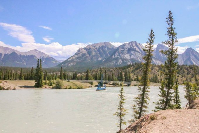
The Saskatchewan River and suspension bridge
Fast forward to this June. I had the chance to redeem myself. We were camping nearby again and I decided I’d be amenable to give it another go. Better prepared with rain gear, bear spray, a few snacks and confidence from recent successful hikes where I didn’t get eaten or lost forever, we trekked out. I made it over the bridge, through the meadow and boardwalk and actually made it to the Siffleur River Bridge (that last time I’d mistakenly thought was the waterfall nearby). I carried in bravely even thought the trail was again, not very busy and began to close in with thick brush. We followed the trail and passed warning signs that we were now in back country. In quiet, densely forested areas, I requested that Shawn tell me very LOUD STORIES as we headed further back into the mountains. We came to a bit of a fork with 2 trails with a trail head marker that was not longer there. After some discussion we decided to take the trail that looked more “used”.

Crossing the Saskatchewan River

Suspension bridge at the Saskatchewan River

This took us up a steep trail and I realized we’d been walking for a while and was surprised to hear the sound of rushing water getting quieter, which I thought was odd, since we were hiking to falls. There were few markers and the obvious paths were getting less clear. My Garmin activity tracker told me we’d been hiking for well over 4km at this point so we checked the rudimentary map we’d gotten from the campground. It was then that we noticed the map (unlike the others we’d gotten for other nearby hikes) was listed in “hours” and not kilometers or miles. We didn’t have any idea how long we’d been hiking for, but guessed about 45 mins to an hour. The location of our falls was listed at 2.5 hours, which would make this at very least, a 5 hour return trip. Even though I’d prepared better, I hadn’t brought extra clothes or enough food to spend a night (worst case scenario in the mountains). There were very few other hikers and no cell service in case something happened. We hadn’t let anyone know we were on a hike, as we hadn’t expected this one was so long. We hadn’t set out particularly early and if we ate our snack on the way, we would have had nothing else for an emergency situation. Since we had no idea how much longer the hike would take (at this point we were starting to wonder if we were still on the correct path) and since we still weren’t prepared for a potential night in the back country, we decided to turn back.
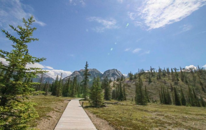
Boardwalk along the first part of the Siffleur Falls hike

Getting into backcountry

Leaf miner damage on some of the leaves

Wild Orchids! Beautiful!

Round leaf orchid
I was again, very disappointed in myself, but at least this time I didn’t turn back because I let irrational fears get the best of me. Maybe I was over cautious about the potential things that could go wrong, but I also didn’t want to be a statistic and need rescuing from a mountain park. In my frustration about still not making it to the damn falls, I have to keep in mind that we didn’t have great information from the map or the trail information at the trail head and I can use that as a lesson for the next time. When we returned and checked to see if we’d missed something obvious, we noticed that someone had written 4.4 km by hand on the map. Obviously, that’s not the kind of information one can necessarily trust either; who wrote it? How did they track it?

A beauty day for a hike

Crossing the Siffleur River bridge
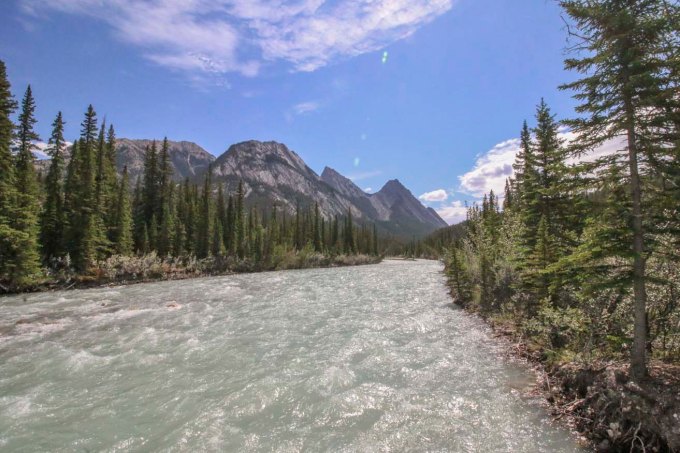
Siffleur River

Siffleur River

Hiking back after turning around

Star-flowered False Solomon Seal

Red Paintbrush. One of my favorite alpine wildflowers
So Siffleur falls wins again. At the end of the day, we’d had a nice hike, the views were stunning, we found gorgeous flowers and I’m happy that I made it farther than last time. Maybe the third time will be a charm, with an early start, a full pack and a big can of bear spray.
Have you made it to Siffleur Falls? How was your hiking experience? Have you ever encountered misinformation about a trail? Thanks again for stopping by to read. Feel free to comment or ask questions! Until next time, safe and happy travels!
-L
Staycation Alberta: Roadtrip to Ram Falls
Posted on July 7, 2018
 Last year I had surgery and was off work for 6 weeks. Towards the end of my leave I was getting cabin fever so my Mom offered to take me on a road trip; something easy, she would drive, all I had to do was sit in the car and walk around when we got out for stops along the way. Mom lives in Red Deer, Alberta which is pretty much in the middle of our province. It’s a pretty easy drive to get to the mountains if you head west, and that’s what I wanted to do. She remembered having done a trip to Ram Falls out near Nordegg, Alberta, decades earlier, so we decided on that. We packed a lunch and brought my dog, Lexi along for the adventure.

We headed out west from Red Deer fairly early. According to the GPS maps, we guessed it would take about 2 hours to drive there. Since Ram falls is tucked fairly deep into the foothills of the mountains, Mom suspected the roads may be secondary highways or even gravel trunk roads that would be less maintained than the main highways. We made our way out on Highway 11\22, turned onto Township road 392 and then a left at AB-782 W. It was our plan to meet up with Forestry Trunk Road AB-40 but that didn’t happen. The trunk road at 752 did turn into a gravel road, as Mom expected and it was rough. Really rough. She put her foot down (not literally) and turned the car around. Because I was still recovering from surgery, she was concerned the bumpy road was not conducive to my condition. I’m not going to lie; I was mad.

The gravel trunk road out to Ram Falls
I was so excited to take a back road; mysterious and serene, to explore the wilderness. We headed back south on highway 766 and were deciding what to do instead, but I was really upset; I’d been cooped up all spring and would have to work through most of the summer once I went back to work and I really wanted to do this trip. We argued about it a bit and Mom remembered that there may be a secondary route to get to Ram Falls, and finally agreed to try the alternate route, as long as the gravel roads there were less bumpy. YAY!
We re-routed and headed out on highway 54 through the small town of Caroline. Caroline Alberta is located in Clearwater County, and it’s kind of the unofficial “Sasquatch corridor” of the province. Many Bigfoot sightings get reported here.


I’m serious; there are dedicated blog sites and eyewitness accounts of Bigfoot sightings. Honestly, its so densely wooded and starts to get isolated from town with the foothills of the mountains beginning here, it makes a person wonder what could be lurking in the forests… But the county seems to have used the Bigfoot rumors in a clever way, with the Sasquatch and Partners program. Their message of environmental stewardship draws attention to looking after nature and being respectful, safe, and ecologically sound while enjoying the wilderness. There were quite a few Sasquatch signs and memorabilia as we headed west. Makes a person think…..

Anyway, we did finally hit another gravel road as we continued onto highway 591, but Mom and I agreed that this road felt less bumpy but she warned me that if she thought it was getting worse she would again “turn the car around”. Luckily, there weren’t too many bad spots and she drove slowly in some of the rutty spots. Along the way we passes a lot of off-the-grid campers. We hadn’t yet reached the area that becomes a provincial park area, and while I’m not sure if legal, there were plenty of campers, ATVs, and all manner of “toys” pulled off the road at makeshift camp sites. I’d highly advise a full tank of gas and a spare tire or two (with the knowledge of how to change it) for this trek, but there was enough traffic that we weren’t completely alone. Even so, it was still a pretty quiet, back country drive. We drove through some pretty farmland, rolling hills with Texas gates and saw lots of free roaming horses and cattle.


We stopped for a picnic lunch at Elk Creek, a tiny, remote, unserviced campground. What a pretty spot. So quiet you just hear wind rustling through thousands and thousands of pine trees. Some pretty birds hung around and a few chipmunks that clearly know that people have delicious snacks paid us a visit. We explored around Elk Creek and stretched our legs before continuing.

Lunch at Elk Creek

Mom and Lexi
As we got close to Ram Falls, the roads started to get steeper and more mountainous. The landscape opened up and as we crested one hill, down below the hillsides and carved out ravines we began to see were black. Stunning and a bit spooky, apparently these rocks are formed from a different type of shale than in a lot of the rock found in the rocky mountains further west.

Black shale rock

There is a cool orange covered bridge that crosses the South Ram River which contrasts beautifully with the black shale rock hillsides. You might spot a few mountain sheep along the hillside and roadway, if you’re lucky.

Crossing the South Ram River
The entrance to the Ram Falls lookout point is slightly further past the covered bridge and is well marked. We weren’t sure how accessible the falls lookout point was from the parking area. Mom certainly didn’t want me doing a long hike through rough terrain to get to the falls. She stopped a fellow visitor who told us it was a short, easy walk to a well built staircase down to the falls. Mom didn’t let me go down the entire staircase, so if you go, you’ll get an even better view of the falls than I did. Ram River Falls are quite stunning.


Ram River Falls


 Had I not been on medical leave, I would have loved to go all the way down to get a better view, but in addition to my recent surgery, Lexi wasn’t a big fan of all the steps and the open railings. While totally safe for people, it would have meant a big drop off if the small dog had missed a step or sniffed too far over the edge. We spent about an hour at the falls and then headed back out on highway 374/AB-40 north which was still gravel until we got to Nordegg, where we stopped again for a bathroom break and a stretch.


Heading back home through Nordegg
 The Nordegg area has a lot of great camping spots. A lot are unserviced, but if you can live off the grid for a few days, you won’t be disappointed.

A distant prescribed burn in the Rocky Mountains

The route we took
Because of our backtracking and little detour down through Caroline, we used a good portion of the day and didn’t get back to Red Deer until after dinner. It was a great day, spending quality time with Mom and Lexi in pristine, nearly untouched nature. I can’t wait to go back and camp at Elk Creek, and I think you should too. Have you been out this way? What’s your favorite camping spot? Drop me a line if you like, and happy travels!


All Photos © Eterno Dia Photography and Leslie Pallier Winter 2018.
