Diving Into Thailand
Posted on April 1, 2019

I am not an experienced diver. I’m not certified. I only started to learn to swim 3 years ago; I took adult swim lessons at my local city pool when I turned 35. I love the water but I’m new at this. I’ve done a few “Discover Scuba” classes in the pool and my husband and I had a successful dive in Antigua about 3 years ago.

When planning our trip to Thailand, I knew we had to book a dive. While there are certainly other dive Meccas throughout the world, I know Thailand is pretty high up on the list. I booked our two-dive day months before the trip to make sure we would get the chance, as we had a pretty tight itinerary for our 21 days in Thailand. After some debate, we actually booked it for the first full day we were in Thailand. We knew we’d be exhausted from the 17 hours of flying, jet lag and culture shock, but I was confident I’d at least be healthy at the start of our trip, and I didn’t want to run out of time if our first week on the 7-day tour of the island area of Thailand ended up being too busy.
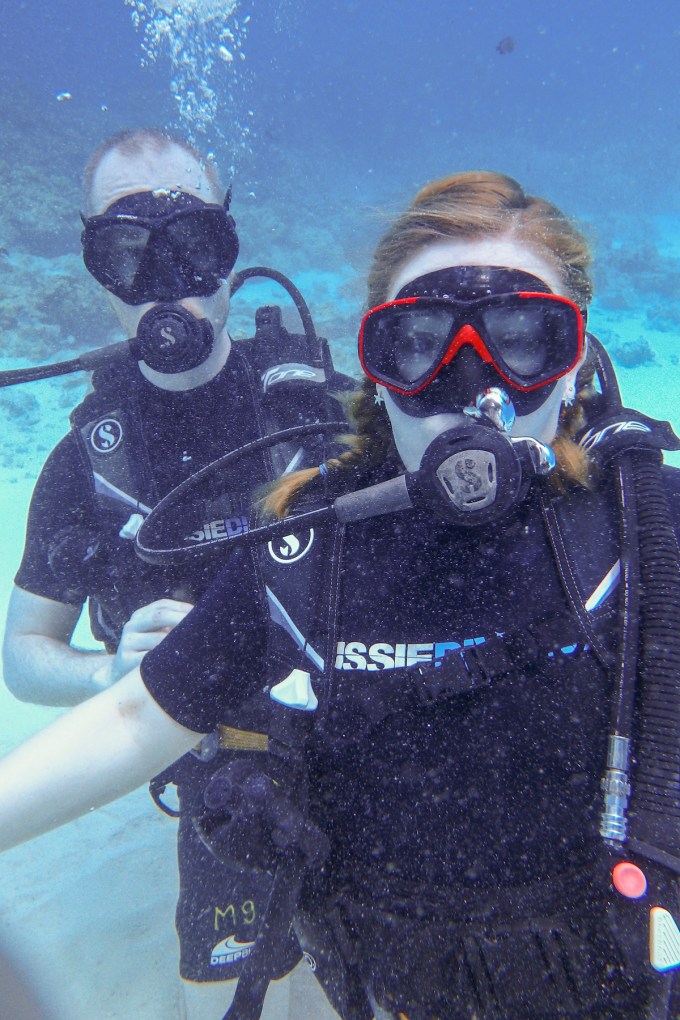
Even though we’d done a refresher discover scuba pool dive at home a few weeks beforehand, I was still really nervous; the ocean is a big place compared to a pool. We’d booked Aussie Divers in advance and it went perfectly from the moment the driver picked us up at our hotel to take us to the pier where we met our dive team of two and our other two fellow divers. We boarded a fairly large boat at the pier with about three other small dive groups. They supplied us with motion sickness tablets (if we needed them), served us a great Thai breakfast and our group went over the basics of hand signals and safety and gave us a general idea of what the day would look like. Afterwards, we had about an hour before reaching the Racha Yai dive site. I didn’t want to sunburn out on the top sundeck knowing I’d be in the water all day so I decided to take a few moments to myself for some relaxation and to calm my anxious nerves. The ocean is my favorite place to be, so what better place to work on myself and practice some mindfulness than during my short time at sea. I put my feet up, leaned against the wall of the booth on the boat and just took in the sounds and sensations around me:

A hint of diesel smell in the air
The dampness of the humidity on my skin
The noisy, chugging boat engine
The choppy waves
The rotating ceiling fan blowing air around the room
The blue of the sky out of the window
The vibration of the boat motor against my skull where I was leaning
The creaking noise of the boat with each wave
I began to feel the boat move with the ocean. I could feel the panels of the boat swell with each wave. I became suddenly aware it felt as if the boat was breathing with the rhythmic waves. I realized I was breathing with it. I closed my eyes and felt the boat and the ocean breathe around me. I felt so peaceful and present.
My session came to an end as we reached our first dive site and Shawn came to see if I was alright because I was alone in the cabin and not mingling on the deck. For a few moments, I had truly been alright. I hadn’t worried about the dive or heatstroke or sea sickness or any of my life worries. I just breathed. Peace.
The dives were amazing. Shawn and I each had a few moments of panic at different times, but the instructors, Darren and Craig, were both professional and helped us work through our issues. The fish were spectacular, the coral was far better than I’d been warned about due to recent storms and climate change. I’m really glad I didn’t know much about triggerfish until later… I’ll let the photos speak for themselves with only one final thought: Be kind to the ocean. Don’t litter, use biodegradable sunscreen and don’t harass the wildlife; it’s their home and we’re privileged to get to see from this view. Be kind to the Earth. We only have one home.


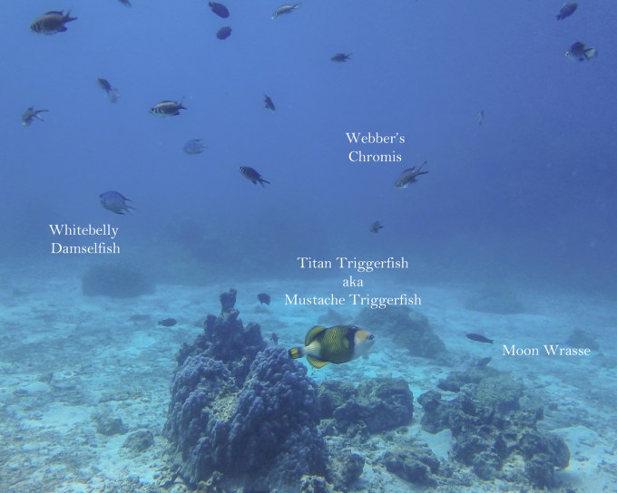
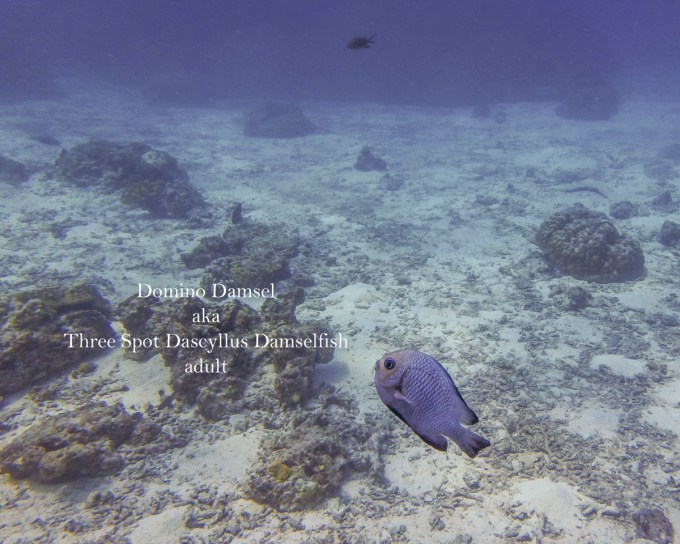

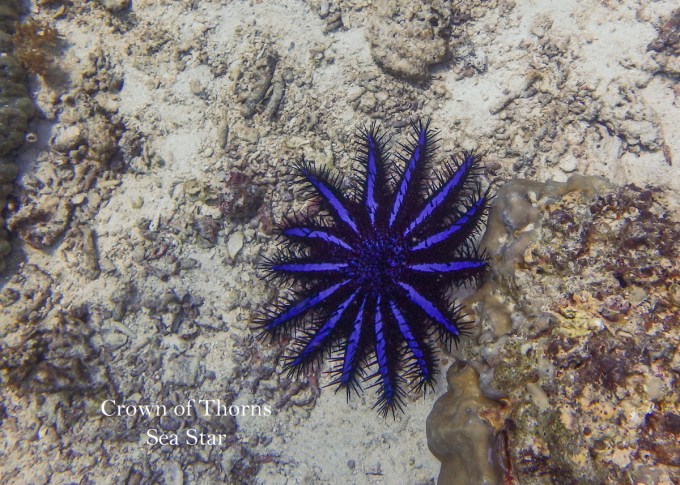


Fun fact: it took me weeks and weeks to research and figure out the names for all the fish we saw that day. Thanks as usual for taking the time to read and look at my photos. This was a really special day for us and I can’t thank Aussie Divers enough for an amazing trip. Stay tuned for more Thailand ramblings. Until next time, safe and happy travels!
Staycation Alberta: Why It’s Always The Right Time To Visit The Mountains
Posted on March 25, 2019

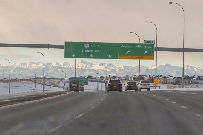
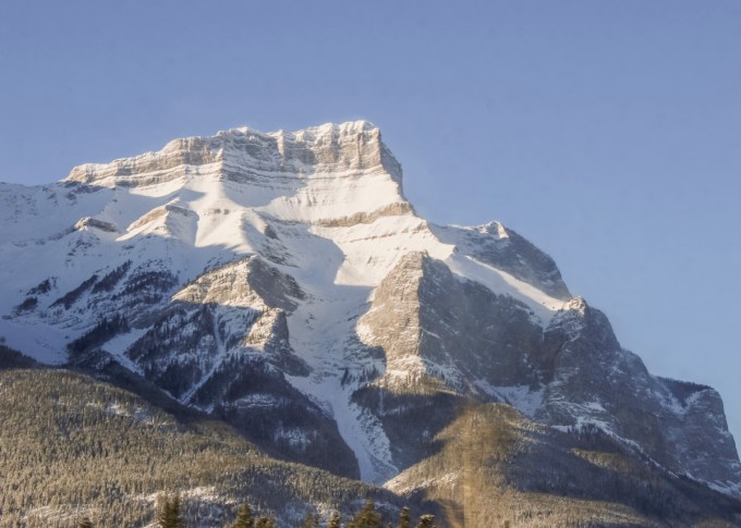
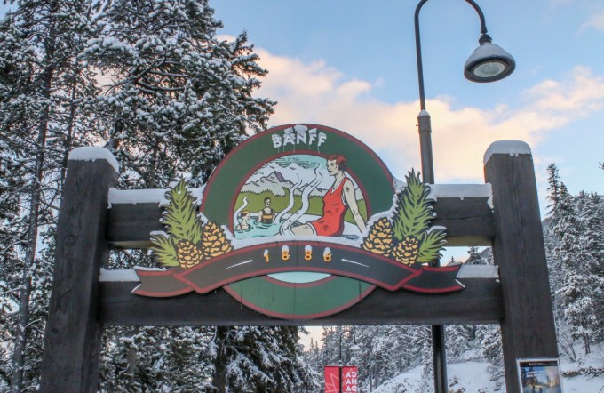
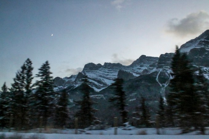
Even though it seems like spring is on the way in Alberta, it doesn’t look it yet in a lot of places. There’s still plenty of snow and it will likely be weeks before we get spring buds. We had a hard winter and it still looks very much like it. Even though you might be looking forward to a glorious, warm summer vacation of camping and hiking in Alberta’s Rocky Mountains, I’m here to convince you that you don’t need to wait, especially if you need a mini vacation, now. The mountains are wonderful any time of year and hold a certain magic in the winter and off seasons that’s quite different from their summer majesty. Last year, just before Christmas I needed a getaway from all of the holiday madness, so we drove to Red Deer and picked up my mom and headed off to Banff, just for the day.


Here are a few reasons you should consider going the the mountain parks now:
- It’s way less crowded (and cheaper) in off season. You won’t have trouble finding parking at some of the attractions and in places like downtown Banff, Canmore or Jasper that are inundated with tourists in the high season. During the low season, “off-season” or “shoulder season” which starts around October and lasts until mid-June, the price of accommodations will be much lower than the inflated prices during the high season. If you’re on a budget, this is a great way to see the mountains.


- There’s plenty to do. Even though some trails or passes are closed due to large amounts of snow, there are still plenty of trails that are usable and again, way less crowded in low and shoulder season. If you’re not into the cold or like a slower pace, there are also lots of interesting “indoors-y” things to do; go to the Banff Art Centre, explore the majesty and history of the Fairmont Banff Springs Hotel. If you’d like to get your science on, visit the Banff Park Museum, or Canmore’s Museum and Geoscience Centre. If you’re up for more adventure, there’s plenty to find in the winter, spring and fall. Canmore offers year round cave tours. Guided hikes, snowshoeing and sled dog tours are readily available in all of the mountain parks. Whether you’re a skier, ice climber or hiker, there’s no limit to the fun outdoor activities you can do in low season.


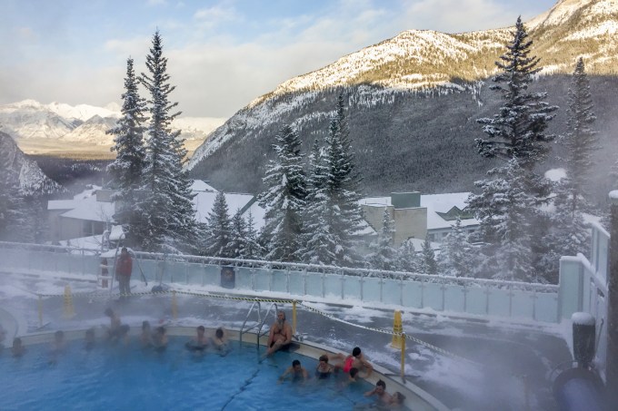
- Rest and relax. The Miette Hot Springs in Jasper and the Upper Hot Springs in Banff are open nearly every day of the year and are delightfully soothing and steamy in the crisp mountain air. After your soak, you could treat yourself to a massage and a coffee or drink at one of these mountain town’s cozy coffee shops or pubs. Rent a cute cottage in Jasper or Canmore and snuggle up with a good book next to the fire with a view that can’t be beaten.


- Take in a festival or local events. All throughout the winter and shoulder seasons, the mountain towns have great festivals. Things like dark sky events to watch for northern lights or learn night sky photography (which is hard to do in the larger cities and during Canada’s long, bright summer evenings) are common events. There are often things like ice sculpture festivals, the Alpenglow Festival and beer and food festivals like the Cochon555 Culinary Weekend. Every fall, Jasper Alberta hosts the Jasper Dark Sky Festival
- Avoid the Bears. If you’re like me, hiking can be anxiety inducing. I’m really afraid of bears. In the winter months those killing machines (I kid. Cardiovascular disease, car accidents and bee and wasp stings kill more people a year than bears) are asleep, so you can wander to your heart’s content. You’ll still be able to see other animals though like, elk, cougars, lynx, owls, moose and deer, so be cautious and respectful but bring a camera and enjoy the bear respite.
Whatever season you decide to visit the Rocky Mountains, always pack warm, layered clothing and emergency supplies for your vehicles. Even in the summer, the elevation can cause the weather to change drastically in just minutes. We got caught in a surprise blizzard on our drive back near Airdrie, Alberta and it was quite scary for a few hours.
Our one day, mini “staycation” in Banff was perfect. We started out early, made it in time for a nice lunch in a cozy pub. Despite the cold, we walked around town for a little while, took in the charming holiday atmosphere and did some Christmas shopping. Before heading home we had a nice soak at the Banff Upper Hot Springs. A perfect tiny escape was just what we all needed.
Have you visited Alberta’s Rocky Mountains before, or do you have plans to? Feel free to comment or ask questions. Thanks for stopping by! Until next time, safe and happy travels!
-L


Staycation Alberta: The Canmore Grassi Lakes Hike
Posted on August 25, 2018

In June, Shawn and I had a four day stretch off together and decided to go to Canmore, located in the Rocky Mountains of Alberta. Canmore is a lovely place for a getaway. A four hour’s drive from Edmonton and one hour west of Calgary, it isn’t quite within the boundaries of Banff National Park, so you don’t have to pay the daily National Park fee if you stay here. There is so much to find in Canmore with the Three Sisters mountains resting gracefully as your backdrop; great shopping, fantastic restaurants and breweries, a museum, gemstone and caving tours, hiking, biking, rafting and more. Eating and accommodations can be as casual or upscale as you like; camping to five star hotels and anything in between. You can keep it as laid back or as classy as you like.
On this trip Shawn convinced me to hike. If you’ve read any of my previous blogs you’ll know that hiking is a bit of an issue for me; you can read all about that in this article. I have a thing about bears that makes me a pretty anxious hiker. Shawn wanted to try the Grassi Lakes hike, a very popular one, which was fine with me; potentially more people I can outrun.  We arrived at the trail head around nine in the morning, after a fairly easy drive up the Three Sisters Parkway Road. When we arrived I was shocked to discover that ours was one of only three other cars in the parking lot. I quickly came to the conclusion that meant that we would be fairly alone on the hike up. This made me very nervous, and I expressed that in no uncertain terms. After a bit of whining, I was convinced that we should still go; after all, I had my trusty bear spray, so no problem.

No one around….

Why am I doing this?!

Mount Rundle
Each step we got further from the car, I got more anxious; hearing noises off in the bushes, smelling “a musty smell” I was convinced was a bear looming around the next corner, waiting to devour me. I remembered that we needed to make noise when in bear country, so I begged Shawn to tell me stories. I picked two “killing rocks” which I started to clack together to make more noise. When that didn’t work, I asked him to play some music on his phone.


Ha Ling Peak

View back to Canmore
The music and storytelling began to calm me, and as we climbed higher and the stunning vistas and views became more grand, I became more distracted by all the beauty. We took the “easy” trail up; a wide, well maintained, access road, and it was a good, steady incline that took us about an hour. It was a gorgeous, warm day and we stopped a few times for water breaks and to remove jackets and scarves. As we crested the final hill to our destination, we found quite a number of hikers already at the lakes. Some had taken the more difficult trail route up but some had come earlier and just stayed a while, and I could see why.


The two lakes at the top that surround the east end of Mount Rundle are simply gorgeous; clear, turquoise ponds that were as still as glass. I could see every detail under the water, right down to the bottom. Mount Ha Ling and Mount Rundle still towered above us. We took our time walking slowly around the first lake and soaking in the tranquility.

Grassi Lake

Grassi Lake

Grassi Lake

Grassi Lake

Crystal clear water

Grassi Lake
Up to the left of where we were at the lakes there was a giant, silver, man-made pipe. This is a pipe so large you can see from the main highway down at the town site and I’d always wondered what it was whenever we’d driven through the area. We had no idea what it was and hiked a few hundred yards further up to explore it. As it turns out, the town of Canmore gets part of its water supply from the Spray Lakes Reservoir in the the Spray Valley Provincial Park high above the town of Canmore. The tube we found is part of the Three Sisters Hydroelectric Plant that controls the reservoir and helps to move water from the Spray Lakes above to Whitemans Pond and then down to the Quarry Lake reservoir down below.


We carried on to further explore when we began to hear rumors from other hikers that there was a nesting owl nearby. I’ve never seen an owl outside of a zoo before and I’d been waiting for years to see a wild one. In addition to being a bit of a birder, my grandma was mad about owls. She had owl trinkets, owl jewelry, china, clothing, figurines, paintings; you name it. She was obsessed. Ever since her passing, I’d been hoping to see an owl one day; a real, wild owl. When we heard about the owl, I was so excited, I couldn’t hold my camera steady; my hands were shaking so hard I had to get out my tripod. I was so worried she’d be in a tree and fly away before I’d get a chance to see the owl I’d waited so long for. We rushed to the a spot where we could see the cave it was pointed out that she was nesting in high on the very east end of Mount Rundle, and there she was, posed like a proud statue. I was so overcome with emotion that I burst into tears, much to the shock of the hikers around me. Here was the owl I’d been waiting to see; napping in her cave at the edge of the cliff. Through the tears, I managed to get my telephoto lens on my camera, found some level ground and started photographing.

Great Horned Owl in her cave on Rundle Mountain
I probably spent an hour just taking photos of the owl and pointing her out to other hikers. At one point, a fuzzy, grey blob waddled out beside her; one of her owlets (we were told by others that there was more than one baby) came out to gaze sleepily about and then retired as quickly as he came. After some length of time, Shawn implored me to continue to explore the rest of the area. Along the upper edge we found group of climbers scaling the side of Mount Rundle. We hiked back down to the first lake and I pointed out to every hiker we passed how to find the owl as they went up.

Great Horned Owl

Great Horned Owl

Preening

Happened to catch a swallow zooming passed

Well, hello!

Seems unimpressed by his audience

Those eyes though…
We decided to take the “difficult” route back down. The difficult path was significantly more taxing than the way up. It had steep steps, sharp cutbacks, slippery spots, but also stunning views looking down on the town of Canmore. A fellow hiker whom I’d talked with about the owl told me where to find lady slipper orchids on the way back down.


Whitemans Pond and the parking lot below


Ha Ling Peak behind the waterfall

Whitemans Pond – The reservoir for water collected from the Spray Lakes above.
We made it safely down, with no bear encounters, but some absolutely amazing views, and a thrilling encounter with a truly stunning owl, who has apparently nested there for the past several years. Grassi Lakes was definitely a gem of a hike. Easy enough for the inexperienced hiker but as challenging as you’d like it to be. Don’t miss this delightful hike, and remember to look up on the side of Rundle Mountain as you reach the upper lake, to spot this lovely owl and maybe and owlet or two.

Lady Slipper Orchids! I didn’t even know there were orchids in Alberta!


Have you done this hike? What other hikes in the Canmore area do you recommend? As always, feel free to share, comment and ask questions. Until next time, happy traveling!

A successful hike. So gorgeous!

A well earned beverage at one of Canmore’s fine pubs post-hike.
Staycation Alberta: Roadtrip to Ram Falls
Posted on July 7, 2018
 Last year I had surgery and was off work for 6 weeks. Towards the end of my leave I was getting cabin fever so my Mom offered to take me on a road trip; something easy, she would drive, all I had to do was sit in the car and walk around when we got out for stops along the way. Mom lives in Red Deer, Alberta which is pretty much in the middle of our province. It’s a pretty easy drive to get to the mountains if you head west, and that’s what I wanted to do. She remembered having done a trip to Ram Falls out near Nordegg, Alberta, decades earlier, so we decided on that. We packed a lunch and brought my dog, Lexi along for the adventure.

We headed out west from Red Deer fairly early. According to the GPS maps, we guessed it would take about 2 hours to drive there. Since Ram falls is tucked fairly deep into the foothills of the mountains, Mom suspected the roads may be secondary highways or even gravel trunk roads that would be less maintained than the main highways. We made our way out on Highway 11\22, turned onto Township road 392 and then a left at AB-782 W. It was our plan to meet up with Forestry Trunk Road AB-40 but that didn’t happen. The trunk road at 752 did turn into a gravel road, as Mom expected and it was rough. Really rough. She put her foot down (not literally) and turned the car around. Because I was still recovering from surgery, she was concerned the bumpy road was not conducive to my condition. I’m not going to lie; I was mad.

The gravel trunk road out to Ram Falls
I was so excited to take a back road; mysterious and serene, to explore the wilderness. We headed back south on highway 766 and were deciding what to do instead, but I was really upset; I’d been cooped up all spring and would have to work through most of the summer once I went back to work and I really wanted to do this trip. We argued about it a bit and Mom remembered that there may be a secondary route to get to Ram Falls, and finally agreed to try the alternate route, as long as the gravel roads there were less bumpy. YAY!
We re-routed and headed out on highway 54 through the small town of Caroline. Caroline Alberta is located in Clearwater County, and it’s kind of the unofficial “Sasquatch corridor” of the province. Many Bigfoot sightings get reported here.


I’m serious; there are dedicated blog sites and eyewitness accounts of Bigfoot sightings. Honestly, its so densely wooded and starts to get isolated from town with the foothills of the mountains beginning here, it makes a person wonder what could be lurking in the forests… But the county seems to have used the Bigfoot rumors in a clever way, with the Sasquatch and Partners program. Their message of environmental stewardship draws attention to looking after nature and being respectful, safe, and ecologically sound while enjoying the wilderness. There were quite a few Sasquatch signs and memorabilia as we headed west. Makes a person think…..

Anyway, we did finally hit another gravel road as we continued onto highway 591, but Mom and I agreed that this road felt less bumpy but she warned me that if she thought it was getting worse she would again “turn the car around”. Luckily, there weren’t too many bad spots and she drove slowly in some of the rutty spots. Along the way we passes a lot of off-the-grid campers. We hadn’t yet reached the area that becomes a provincial park area, and while I’m not sure if legal, there were plenty of campers, ATVs, and all manner of “toys” pulled off the road at makeshift camp sites. I’d highly advise a full tank of gas and a spare tire or two (with the knowledge of how to change it) for this trek, but there was enough traffic that we weren’t completely alone. Even so, it was still a pretty quiet, back country drive. We drove through some pretty farmland, rolling hills with Texas gates and saw lots of free roaming horses and cattle.


We stopped for a picnic lunch at Elk Creek, a tiny, remote, unserviced campground. What a pretty spot. So quiet you just hear wind rustling through thousands and thousands of pine trees. Some pretty birds hung around and a few chipmunks that clearly know that people have delicious snacks paid us a visit. We explored around Elk Creek and stretched our legs before continuing.

Lunch at Elk Creek

Mom and Lexi
As we got close to Ram Falls, the roads started to get steeper and more mountainous. The landscape opened up and as we crested one hill, down below the hillsides and carved out ravines we began to see were black. Stunning and a bit spooky, apparently these rocks are formed from a different type of shale than in a lot of the rock found in the rocky mountains further west.

Black shale rock

There is a cool orange covered bridge that crosses the South Ram River which contrasts beautifully with the black shale rock hillsides. You might spot a few mountain sheep along the hillside and roadway, if you’re lucky.

Crossing the South Ram River
The entrance to the Ram Falls lookout point is slightly further past the covered bridge and is well marked. We weren’t sure how accessible the falls lookout point was from the parking area. Mom certainly didn’t want me doing a long hike through rough terrain to get to the falls. She stopped a fellow visitor who told us it was a short, easy walk to a well built staircase down to the falls. Mom didn’t let me go down the entire staircase, so if you go, you’ll get an even better view of the falls than I did. Ram River Falls are quite stunning.


Ram River Falls


 Had I not been on medical leave, I would have loved to go all the way down to get a better view, but in addition to my recent surgery, Lexi wasn’t a big fan of all the steps and the open railings. While totally safe for people, it would have meant a big drop off if the small dog had missed a step or sniffed too far over the edge. We spent about an hour at the falls and then headed back out on highway 374/AB-40 north which was still gravel until we got to Nordegg, where we stopped again for a bathroom break and a stretch.


Heading back home through Nordegg
 The Nordegg area has a lot of great camping spots. A lot are unserviced, but if you can live off the grid for a few days, you won’t be disappointed.

A distant prescribed burn in the Rocky Mountains

The route we took
Because of our backtracking and little detour down through Caroline, we used a good portion of the day and didn’t get back to Red Deer until after dinner. It was a great day, spending quality time with Mom and Lexi in pristine, nearly untouched nature. I can’t wait to go back and camp at Elk Creek, and I think you should too. Have you been out this way? What’s your favorite camping spot? Drop me a line if you like, and happy travels!


All Photos © Eterno Dia Photography and Leslie Pallier Winter 2018.
Tales Of An Angry Chipmunk
Posted on July 25, 2013
I was camping out near Nordegg, Alberta in June. I heard some incessant chirping and when I went to investigate I was surprised to find this angry little chipmunk instead of a bird. He led me around for a few minutes before he scurried off into the brush, all the while telling me how upset he was. Enjoy!
