Staycation Alberta: Siffleur Falls and the story about how I never made it there twice
Posted on August 31, 2019
 I’m not much of a hiker, but I’m working on my irrational fear of bears and I always try to do things that scare me in order to deal with and conquer my fears. I’ve come a long way in the past few years with a successful 17 km round trip to both tea houses at Lake Louise three years ago and a successful hike to the gorgeous Grassi Lakes in Canmore last year.
About six years ago was one of my first attempts at a hike in bear country since my fear started. My husband and I and our pug Lexi, were on a camping trip at David Thompson Resort and Shawn wanted to try a hike. We’d heard about the popular Siffleur Falls hike nearby and it sounded doable. Back then, I didn’t carry bear spray and I was an ill prepared hiker.

I did okay for the first 20 or so minutes. We crossed the suspension bridge that crosses the Saskatchewan River. I began to get anxious when we got to the boardwalk area, which seemed like the perfect meadow area for bears to be at home in. My anxiety peaked when we reached a narrow closed in section of the trail where I couldn’t tell if my fear was overtaking me or if the feeling I was having of feeling “watched” was paranoia or was my instincts- it’s sometimes said if you feel like you’re being watched, you could be being stalked by a predator- and they have mountain lions here too. Even though I thought I could hear the waterfall ahead, my fear became too much with the trail being not densely populated and with my appetizer of a dog, I forced our little family to turn around. Even though I was alive, I was really disappointed in myself for letting my fear run wild.

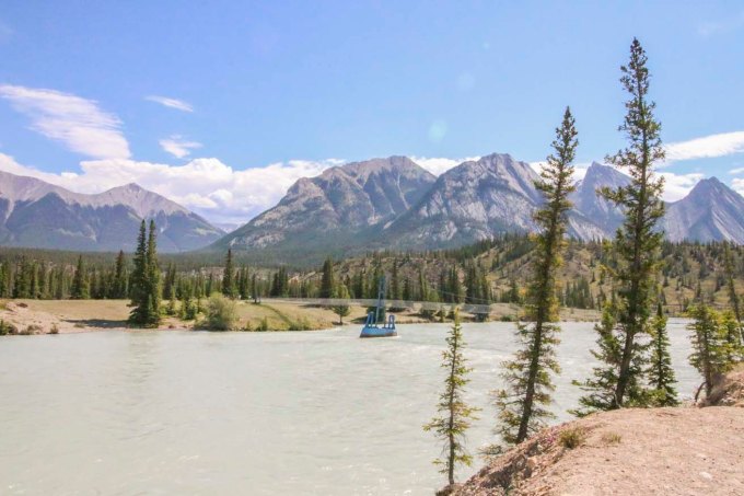
The Saskatchewan River and suspension bridge
Fast forward to this June. I had the chance to redeem myself. We were camping nearby again and I decided I’d be amenable to give it another go. Better prepared with rain gear, bear spray, a few snacks and confidence from recent successful hikes where I didn’t get eaten or lost forever, we trekked out. I made it over the bridge, through the meadow and boardwalk and actually made it to the Siffleur River Bridge (that last time I’d mistakenly thought was the waterfall nearby). I carried in bravely even thought the trail was again, not very busy and began to close in with thick brush. We followed the trail and passed warning signs that we were now in back country. In quiet, densely forested areas, I requested that Shawn tell me very LOUD STORIES as we headed further back into the mountains. We came to a bit of a fork with 2 trails with a trail head marker that was not longer there. After some discussion we decided to take the trail that looked more “used”.

Crossing the Saskatchewan River

Suspension bridge at the Saskatchewan River

This took us up a steep trail and I realized we’d been walking for a while and was surprised to hear the sound of rushing water getting quieter, which I thought was odd, since we were hiking to falls. There were few markers and the obvious paths were getting less clear. My Garmin activity tracker told me we’d been hiking for well over 4km at this point so we checked the rudimentary map we’d gotten from the campground. It was then that we noticed the map (unlike the others we’d gotten for other nearby hikes) was listed in “hours” and not kilometers or miles. We didn’t have any idea how long we’d been hiking for, but guessed about 45 mins to an hour. The location of our falls was listed at 2.5 hours, which would make this at very least, a 5 hour return trip. Even though I’d prepared better, I hadn’t brought extra clothes or enough food to spend a night (worst case scenario in the mountains). There were very few other hikers and no cell service in case something happened. We hadn’t let anyone know we were on a hike, as we hadn’t expected this one was so long. We hadn’t set out particularly early and if we ate our snack on the way, we would have had nothing else for an emergency situation. Since we had no idea how much longer the hike would take (at this point we were starting to wonder if we were still on the correct path) and since we still weren’t prepared for a potential night in the back country, we decided to turn back.
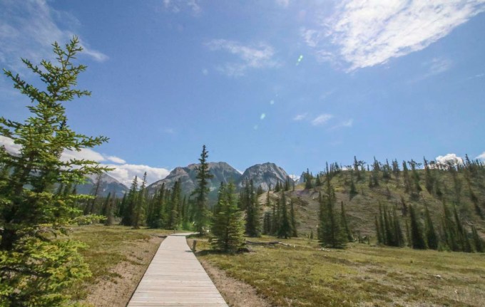
Boardwalk along the first part of the Siffleur Falls hike

Getting into backcountry

Leaf miner damage on some of the leaves

Wild Orchids! Beautiful!

Round leaf orchid
I was again, very disappointed in myself, but at least this time I didn’t turn back because I let irrational fears get the best of me. Maybe I was over cautious about the potential things that could go wrong, but I also didn’t want to be a statistic and need rescuing from a mountain park. In my frustration about still not making it to the damn falls, I have to keep in mind that we didn’t have great information from the map or the trail information at the trail head and I can use that as a lesson for the next time. When we returned and checked to see if we’d missed something obvious, we noticed that someone had written 4.4 km by hand on the map. Obviously, that’s not the kind of information one can necessarily trust either; who wrote it? How did they track it?

A beauty day for a hike

Crossing the Siffleur River bridge
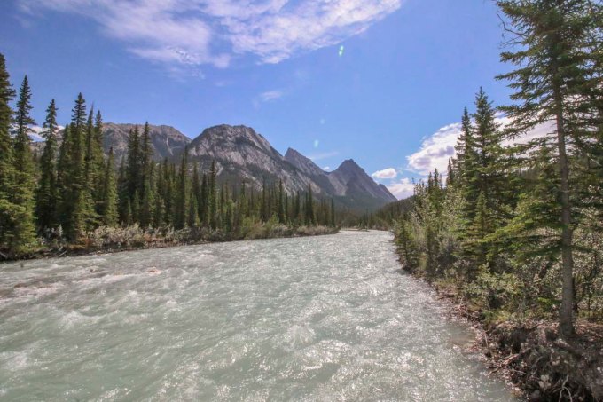
Siffleur River

Siffleur River

Hiking back after turning around

Star-flowered False Solomon Seal

Red Paintbrush. One of my favorite alpine wildflowers
So Siffleur falls wins again. At the end of the day, we’d had a nice hike, the views were stunning, we found gorgeous flowers and I’m happy that I made it farther than last time. Maybe the third time will be a charm, with an early start, a full pack and a big can of bear spray.
Have you made it to Siffleur Falls? How was your hiking experience? Have you ever encountered misinformation about a trail? Thanks again for stopping by to read. Feel free to comment or ask questions! Until next time, safe and happy travels!
-L
Staycation Alberta: The Lake Louise Teahouse Hikes
Posted on June 16, 2018
 I love the beach. But I love the mountains nearly as much. In Alberta we are lucky to have the Rocky Mountain range to the west of the province that travels all the way down to the southern border. Mountains are majestic, mysterious and untamed wilderness. I imagine the creatures living out in the dense forests and hidden up in mountain caves; all there but unseen. The air is so fresh, everything is so much more peaceful but also more grand than I find life in the city. For years I’d been wanting to do the tea house hikes near Lake Louise in Banff National Park. In addition to being an avid tea drinker and enthusiast, I like to stay active, try new things and confront fears. I have a fear that keeps me from hiking. I admit it. I have an irrational fear of bears. I say irrational because I know my odds of being attacked or killed by a bear is extraordinarily low. I have better odds of winning the lottery. Based on the number of actual bear attacks vs. other things that can kill you, you’re approximately one million times more likely to die of something other than a bear attack. It was a personal goal of mine to actually do this hike to confront my bear fear and have a great cup of tea on a mountain. We had a few days in August and decided to finally do the hike.

There are two tea houses to chose from in this area. I had it in mind that if I could make it to the closer, Lake Agnes tea house, it would be a success. The Lake Agnes tea house sits at an elevation of 2135 meters (7005 feet) and was built in 1901 by the Canadian Pacific Railway as a shelter for hikers. They began serving tea in 1905 and it has since been expanded from its original size.

Looking down at the tiny looking canoes on Lake Louise
We started out from the Chateau Lake Louise parking lot at about nine o’clock in the morning. We packed sunscreen, bug spray, BEAR SPRAY, water, hats and a ton of snacks. I don’t have proper hiking boots, but my cross trainers did the trick. We layered our clothes as temperatures in the mountains can go from one extreme to another very quickly, even in August, but fortunately it was a warm day with a nice breeze.

Mirror Lake and the little beehive
The path up to Lake Agnes is wide and well groomed and for most people, considered fairly easy. It’s definitely a steady uphill climb of about 3.6 kilometers (2.2 miles). I struggled with the elevation and stopped to huff and puff and attempt to regain my composure every 5 or so minutes. My husband was barely out of breath. Don’t take my progress as indication of the trail’s difficulty though; there were young children, and parents toting young children on their backs, passing me at an astonishing rate. While I found the uphill part quite strenuous, the views were amazing with lots of lookout stops. The path is very well traveled and is especially busy during peak season (June-August) so I found I really wasn’t concerned about bears. We stopped at Mirror Lake for a rest and took in the amazing views of the big beehive and the waterfall that runs from Lake Agnes.


Lake Agnes
It took about two hours for us to reach Lake Agnes where we stopped for lunch at the tea house. It was crowed with a long wait for tea, but the views were absolutely stunning.

Some hikers decided to take a cold dip in the lake
After a rest, some lunch and a delicious cup of tea, my husband and a staff member suggested we do “the loop”; a trail that connects the Lake Agnes tea house with the trail to the more remote Plains of the Six Glaciers tea house. Now I was thinking about bears. This Plains Of The Six Glaciers tea house is the lesser traveled of the two (and much farther from civilization). I was thrilled with how much I’d already accomplished but I was already tired. The staff member assured me that the rest of the hike (now a one kilometer hike to the Highline Trail that connects to trails, and then another five kilometers to The Plains of The Six Glaciers tea house) was mostly downhill, as the latter tea house is at a lower elevation. I reluctantly agreed. I still felt daunted by the amount of ground left to cover and slightly concerned if we’d make it back before dark but husband convinced me I could do it.


For the first ten or so minutes we were mostly alone. I started to panic about the possibility of bears and if this trail really would be this quiet all the way to the second tea house. The first set of hikers we ran into on the way to the Highline Trail were less than thrilled when I asked if we could “hike near them” due to my bear fear. They agreed with a certain lack of enthusiasm, assuring me that it was a busy trail, especially at this time of year. They all but guaranteed me I wouldn’t see any bears.  Within about 20 minutes it became clear that they were right. There were plenty of people on the trail, and in some spots it was so busy, we had to wait for people to pass on the narrow paths before we could go. The hike to the “Six Glaciers” while, not as strenuous at the start, was a long hike. However, I was constantly distracted by the ever changing mountain vistas, valleys and glaciers ahead of us, and how small the Chateau Lake Louise seemed to be getting behind us. There were amazing flowers, stunning rock walls and gorgeous mountain meadows.

Lake Louise and the chateau getting smaller

Headed to the Plains Of The Six Glaciers tea house

The busy trail to the second tea house


As we got closer to our goal, the uphill portion began again and I was starting to tire. We had hikers on their way back from the tea house give us words of encouragement: “keep going!” “You’re almost there!” “Just around the corner!” That last push was really challenging for me. I was breathing pretty hard and a few swear words escaped me. Just as we were about to make the last corner, a loud mechanical whir interrupted the nature sounds as a medical helicopter swooped up from the valley below and up to our destination, just a bit out of sight.


My morbid curiosity peaked (I’ve worked in medicine for nearly a decade now) and finding out what the medical emergency was gave me the energy for the final push. The rumor mill at the tea house was strong and it seemed that a young girl who’d made it up to the top was feeling too unwell to make to 5 km trek back down. Luckily it didn’t seem to be a life threatening emergency, however I imagine it was an expensive helicopter trip…

Mt. Victoria and the Upper Victoria Glacier
Once the excitement subsided I was actually able to take in the INCREDIBLE scenery before me. Towering mountain cliffs that were so high, yet seemed so close. Stunning glaciers, huge moraines and even though there were many people there, still a sense of peaceful isolation being in such a remote place.

The Mitre
We had sandwiches and local tea at the two story, wooden building built in 1924 by Swiss mountain guides. It originally served as a rest stop for climbers on their way to the Abbot Pass. Both the Lake Agnes tea house and the Six Glaciers tea house to this day have no electricity or running water. Supplies are flown in by helicopter in the spring, and additional supplies are packed in (and waste packed back out) by staff. Baked goods are made in wood stoves fresh each day. We learned in chatting with staff members at both tea houses that they usually work a week at a time at the and live and sleep there for the week. At the end of their week they hike out and take supplies down with them. As I recall, even the outhouse waste gets shipped back down the mountain at the end of the season.

Plains Of The Six Glaciers tea house
We explored around the area after our meal and watched across the valley as huge chunks of ice sporadically detached from the mountain sides and caused avalanches below; a delayed, low, rumbling noise that sounded like thunder and explosions in the distance. We didn’t do the additional one kilometer hike from the tea house to the Abott Pass viewpoint as I was concerned about the five kilometers hike back and it was getting a bit later in the day. If you leave time to do this, most people we spoke to recommended the view.

Once of many avalanches we witnessed high up on the glacier
I hoped the hike down would be easier, but alas, the leg muscles you use to walk down (instead of up) were also fatigued by this point. It was at least a change from the uphill climb, and a gradual downhill hike to get back to lake Louise, but my knees were getting pretty wobbly by the time we hit flat ground again.

Lake Louise and the chateau in the distance
I never thought about a bear the entire way back, and again, the scenery was just stunning. We made it back to our car by about five o’clock and had logged 18 kilometers, 29,803 steps and the equivalent of 95 flights of stairs. It was an amazing day and an exhausting one. I was definitely hurting going up and down stairs and getting in and out of the car the next day but I can honestly say it was worth it to get out there and do something that scared me, physically challenged me and allowed me to experience such stunning beauty. The photos could never do this hike the proper justice it deserves.  I highly recommend you get out there and do one or both of these hikes. If you live in Alberta, go explore our beautiful rocky mountains.If you don’t live here, you really should visit. As usual feel free to comment or ask any questions. Have you done this hike? What did you think? Other hikes to recommend?
Until next time, happy travelling!


