Staycation Alberta: Siffleur Falls and the story about how I never made it there twice
Posted on August 31, 2019
 I’m not much of a hiker, but I’m working on my irrational fear of bears and I always try to do things that scare me in order to deal with and conquer my fears. I’ve come a long way in the past few years with a successful 17 km round trip to both tea houses at Lake Louise three years ago and a successful hike to the gorgeous Grassi Lakes in Canmore last year.
About six years ago was one of my first attempts at a hike in bear country since my fear started. My husband and I and our pug Lexi, were on a camping trip at David Thompson Resort and Shawn wanted to try a hike. We’d heard about the popular Siffleur Falls hike nearby and it sounded doable. Back then, I didn’t carry bear spray and I was an ill prepared hiker.

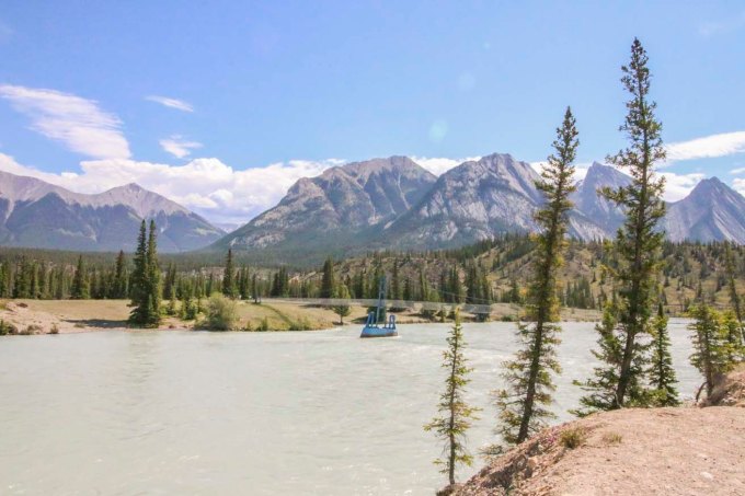
I did okay for the first 20 or so minutes. We crossed the suspension bridge that crosses the Saskatchewan River. I began to get anxious when we got to the boardwalk area, which seemed like the perfect meadow area for bears to be at home in. My anxiety peaked when we reached a narrow closed in section of the trail where I couldn’t tell if my fear was overtaking me or if the feeling I was having of feeling “watched” was paranoia or was my instincts- it’s sometimes said if you feel like you’re being watched, you could be being stalked by a predator- and they have mountain lions here too. Even though I thought I could hear the waterfall ahead, my fear became too much with the trail being not densely populated and with my appetizer of a dog, I forced our little family to turn around. Even though I was alive, I was really disappointed in myself for letting my fear run wild.

The Saskatchewan River and suspension bridge
Fast forward to this June. I had the chance to redeem myself. We were camping nearby again and I decided I’d be amenable to give it another go. Better prepared with rain gear, bear spray, a few snacks and confidence from recent successful hikes where I didn’t get eaten or lost forever, we trekked out. I made it over the bridge, through the meadow and boardwalk and actually made it to the Siffleur River Bridge (that last time I’d mistakenly thought was the waterfall nearby). I carried in bravely even thought the trail was again, not very busy and began to close in with thick brush. We followed the trail and passed warning signs that we were now in back country. In quiet, densely forested areas, I requested that Shawn tell me very LOUD STORIES as we headed further back into the mountains. We came to a bit of a fork with 2 trails with a trail head marker that was not longer there. After some discussion we decided to take the trail that looked more “used”.

Crossing the Saskatchewan River

Suspension bridge at the Saskatchewan River

This took us up a steep trail and I realized we’d been walking for a while and was surprised to hear the sound of rushing water getting quieter, which I thought was odd, since we were hiking to falls. There were few markers and the obvious paths were getting less clear. My Garmin activity tracker told me we’d been hiking for well over 4km at this point so we checked the rudimentary map we’d gotten from the campground. It was then that we noticed the map (unlike the others we’d gotten for other nearby hikes) was listed in “hours” and not kilometers or miles. We didn’t have any idea how long we’d been hiking for, but guessed about 45 mins to an hour. The location of our falls was listed at 2.5 hours, which would make this at very least, a 5 hour return trip. Even though I’d prepared better, I hadn’t brought extra clothes or enough food to spend a night (worst case scenario in the mountains). There were very few other hikers and no cell service in case something happened. We hadn’t let anyone know we were on a hike, as we hadn’t expected this one was so long. We hadn’t set out particularly early and if we ate our snack on the way, we would have had nothing else for an emergency situation. Since we had no idea how much longer the hike would take (at this point we were starting to wonder if we were still on the correct path) and since we still weren’t prepared for a potential night in the back country, we decided to turn back.
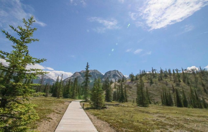
Boardwalk along the first part of the Siffleur Falls hike

Getting into backcountry

Leaf miner damage on some of the leaves

Wild Orchids! Beautiful!

Round leaf orchid
I was again, very disappointed in myself, but at least this time I didn’t turn back because I let irrational fears get the best of me. Maybe I was over cautious about the potential things that could go wrong, but I also didn’t want to be a statistic and need rescuing from a mountain park. In my frustration about still not making it to the damn falls, I have to keep in mind that we didn’t have great information from the map or the trail information at the trail head and I can use that as a lesson for the next time. When we returned and checked to see if we’d missed something obvious, we noticed that someone had written 4.4 km by hand on the map. Obviously, that’s not the kind of information one can necessarily trust either; who wrote it? How did they track it?

A beauty day for a hike

Crossing the Siffleur River bridge
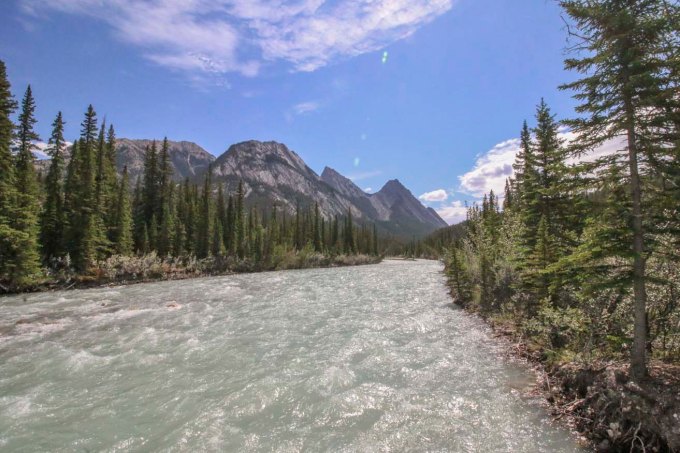
Siffleur River

Siffleur River

Hiking back after turning around

Star-flowered False Solomon Seal

Red Paintbrush. One of my favorite alpine wildflowers
So Siffleur falls wins again. At the end of the day, we’d had a nice hike, the views were stunning, we found gorgeous flowers and I’m happy that I made it farther than last time. Maybe the third time will be a charm, with an early start, a full pack and a big can of bear spray.
Have you made it to Siffleur Falls? How was your hiking experience? Have you ever encountered misinformation about a trail? Thanks again for stopping by to read. Feel free to comment or ask questions! Until next time, safe and happy travels!
-L
Staycation Alberta: The Canmore Grassi Lakes Hike
Posted on August 25, 2018

In June, Shawn and I had a four day stretch off together and decided to go to Canmore, located in the Rocky Mountains of Alberta. Canmore is a lovely place for a getaway. A four hour’s drive from Edmonton and one hour west of Calgary, it isn’t quite within the boundaries of Banff National Park, so you don’t have to pay the daily National Park fee if you stay here. There is so much to find in Canmore with the Three Sisters mountains resting gracefully as your backdrop; great shopping, fantastic restaurants and breweries, a museum, gemstone and caving tours, hiking, biking, rafting and more. Eating and accommodations can be as casual or upscale as you like; camping to five star hotels and anything in between. You can keep it as laid back or as classy as you like.
On this trip Shawn convinced me to hike. If you’ve read any of my previous blogs you’ll know that hiking is a bit of an issue for me; you can read all about that in this article. I have a thing about bears that makes me a pretty anxious hiker. Shawn wanted to try the Grassi Lakes hike, a very popular one, which was fine with me; potentially more people I can outrun.  We arrived at the trail head around nine in the morning, after a fairly easy drive up the Three Sisters Parkway Road. When we arrived I was shocked to discover that ours was one of only three other cars in the parking lot. I quickly came to the conclusion that meant that we would be fairly alone on the hike up. This made me very nervous, and I expressed that in no uncertain terms. After a bit of whining, I was convinced that we should still go; after all, I had my trusty bear spray, so no problem.

No one around….

Why am I doing this?!

Mount Rundle
Each step we got further from the car, I got more anxious; hearing noises off in the bushes, smelling “a musty smell” I was convinced was a bear looming around the next corner, waiting to devour me. I remembered that we needed to make noise when in bear country, so I begged Shawn to tell me stories. I picked two “killing rocks” which I started to clack together to make more noise. When that didn’t work, I asked him to play some music on his phone.


Ha Ling Peak

View back to Canmore
The music and storytelling began to calm me, and as we climbed higher and the stunning vistas and views became more grand, I became more distracted by all the beauty. We took the “easy” trail up; a wide, well maintained, access road, and it was a good, steady incline that took us about an hour. It was a gorgeous, warm day and we stopped a few times for water breaks and to remove jackets and scarves. As we crested the final hill to our destination, we found quite a number of hikers already at the lakes. Some had taken the more difficult trail route up but some had come earlier and just stayed a while, and I could see why.


The two lakes at the top that surround the east end of Mount Rundle are simply gorgeous; clear, turquoise ponds that were as still as glass. I could see every detail under the water, right down to the bottom. Mount Ha Ling and Mount Rundle still towered above us. We took our time walking slowly around the first lake and soaking in the tranquility.

Grassi Lake

Grassi Lake

Grassi Lake

Grassi Lake

Crystal clear water

Grassi Lake
Up to the left of where we were at the lakes there was a giant, silver, man-made pipe. This is a pipe so large you can see from the main highway down at the town site and I’d always wondered what it was whenever we’d driven through the area. We had no idea what it was and hiked a few hundred yards further up to explore it. As it turns out, the town of Canmore gets part of its water supply from the Spray Lakes Reservoir in the the Spray Valley Provincial Park high above the town of Canmore. The tube we found is part of the Three Sisters Hydroelectric Plant that controls the reservoir and helps to move water from the Spray Lakes above to Whitemans Pond and then down to the Quarry Lake reservoir down below.


We carried on to further explore when we began to hear rumors from other hikers that there was a nesting owl nearby. I’ve never seen an owl outside of a zoo before and I’d been waiting for years to see a wild one. In addition to being a bit of a birder, my grandma was mad about owls. She had owl trinkets, owl jewelry, china, clothing, figurines, paintings; you name it. She was obsessed. Ever since her passing, I’d been hoping to see an owl one day; a real, wild owl. When we heard about the owl, I was so excited, I couldn’t hold my camera steady; my hands were shaking so hard I had to get out my tripod. I was so worried she’d be in a tree and fly away before I’d get a chance to see the owl I’d waited so long for. We rushed to the a spot where we could see the cave it was pointed out that she was nesting in high on the very east end of Mount Rundle, and there she was, posed like a proud statue. I was so overcome with emotion that I burst into tears, much to the shock of the hikers around me. Here was the owl I’d been waiting to see; napping in her cave at the edge of the cliff. Through the tears, I managed to get my telephoto lens on my camera, found some level ground and started photographing.

Great Horned Owl in her cave on Rundle Mountain
I probably spent an hour just taking photos of the owl and pointing her out to other hikers. At one point, a fuzzy, grey blob waddled out beside her; one of her owlets (we were told by others that there was more than one baby) came out to gaze sleepily about and then retired as quickly as he came. After some length of time, Shawn implored me to continue to explore the rest of the area. Along the upper edge we found group of climbers scaling the side of Mount Rundle. We hiked back down to the first lake and I pointed out to every hiker we passed how to find the owl as they went up.

Great Horned Owl

Great Horned Owl

Preening

Happened to catch a swallow zooming passed

Well, hello!

Seems unimpressed by his audience

Those eyes though…
We decided to take the “difficult” route back down. The difficult path was significantly more taxing than the way up. It had steep steps, sharp cutbacks, slippery spots, but also stunning views looking down on the town of Canmore. A fellow hiker whom I’d talked with about the owl told me where to find lady slipper orchids on the way back down.


Whitemans Pond and the parking lot below


Ha Ling Peak behind the waterfall

Whitemans Pond – The reservoir for water collected from the Spray Lakes above.
We made it safely down, with no bear encounters, but some absolutely amazing views, and a thrilling encounter with a truly stunning owl, who has apparently nested there for the past several years. Grassi Lakes was definitely a gem of a hike. Easy enough for the inexperienced hiker but as challenging as you’d like it to be. Don’t miss this delightful hike, and remember to look up on the side of Rundle Mountain as you reach the upper lake, to spot this lovely owl and maybe and owlet or two.

Lady Slipper Orchids! I didn’t even know there were orchids in Alberta!


Have you done this hike? What other hikes in the Canmore area do you recommend? As always, feel free to share, comment and ask questions. Until next time, happy traveling!

A successful hike. So gorgeous!

A well earned beverage at one of Canmore’s fine pubs post-hike.
