Freezing in February
Posted on February 10, 2021
Once again, my busy day jobs have been keeping me separated from photography. I’m in health care and since COVID ramped up, I’ve been working so much. I’m behind on posting Thailand blogs (that trip was two years ago!) and lots of little day and weekend trips we were able to go on during the summer when COVID numbers were low in Alberta.

This past week, I did have a small bit of time and energy, and I decided to try frozen bubble photography!

The weather has been perfect for this little experiment; our daytime highs have been around -25° Celsius (-13 Fahrenheit) with a windchill as low as -40° C (-40 F). Most of the prairies (and the rest of Canada) has been locked in a polar vortex for nearly a week, so I had nothing better to do with my time. Frozen bubbles are just that- bubbles you blow up with a straw, like you used to do as a kid, blowing bubbles in your milk. The bubbles quickly begin to freeze and crystallize with beautiful, magical patterns. You can find recipes all over the internet and there are lots of “how-to” videos on YouTube. I used glycerin in mine rather than corn syrup, as that’s what I had available (and I wasn’t going to warm up the car and take a trip for supplies in this weather).

The bubbles are easy to make, especially if you watch a video for advice, and as long as the wind isn’t too strong. My only advice, is to have your equipment, supplies and camera settings all ready, so you don’t have to spend more time than needed outdoors in frigid weather to get your shot. I managed about 20 minutes before my hands were too cold and my bubble solution was getting watered down with ice buildup.


This is a great activity to try with kids, or even on your own. The bubbles are quite magical as they crust over with crystals and develop amazing patterns and striations. If you haven’t tried it, bundle up, get out there and give it a go – it’ll be spring before you know it!

Thanks for stopping by! Stay safe at home, until we can travel the world once more!
-L
Staycation Alberta: Chasing Comets
Posted on July 28, 2020
Comet Neowise surprised astronomers when it was discovered in March of this year. It became popular with the space community and lay people when in July, the comet came close enough to earth the be viewed with the naked eye, or at least a set of binoculars.

Astotin Lake, Elk Island National Park
I had trouble, between Edmonton’s recently very stormy skies, and my myriad of day jobs, finding a chance to head out to hunt for Neowise. Finally, last weekend, I had the time and was blessed with clear skies, so my husband entertained my insanity and we headed 45 minutes east of town to Elk Island National Park, our closest dark sky preserve. We arrived at the park just before midnight as the moon was setting. Even though I was late in the game in terms of catching the comet in its easy viewing phase last week, there were still lots of other folks out in the park that night; stargazers with telescopes far more impressive than mine, astrophotographers, and families enjoying the pleasant July evening.

Watching the setting moon at Astotin Lake in Elk Island National Park.
I’m a photographer, but astrophotography is a whole entity of its own. I follow a lot of communities: The Alberta Aurora Chasers and the Royal Astronomical Society of Canada, just to name a few. The photos from their members are always stunning, but I have ABSOLUTELY NO IDEA what they’re talking about when it comes to equipment and editing. In preparation for trying to capture Neowise on film, I just watched some YouTube videos about how to capture it on a DSLR. I set my camera to the suggested settings before we headed out so that I’d have an idea of where at least to begin so I’d have a chance.

A tiny red meteor streaking though the sky. Red means that the composition is nitrogen and oxygen.
Comet Neowise was no longer naked eye visible, so using all the internet’s suggestions of how to find it, we found a good viewing spot, and started searching with the binoculars. Eventually I found a “smudge”, and Shawn and I both agreed that that was most likely a less than impressive comet. I set up my camera, skeptical I’d even be able to computer it on film, since I couldn’t see it, but I was shocked when I looked at the camera’s screen to have a tiny green comet with a hazy tail appear.
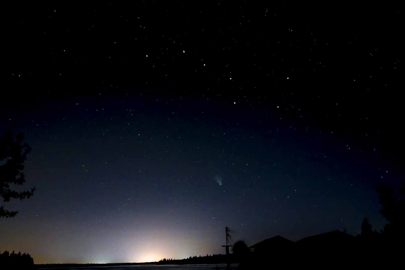
My first glimpse of the Neowise, just below the Big Dipper.

A fellow stargazer looking through a telescope.

Comet Neowise just below the big dipper.
While we were out that night, as it grew darker (the sun never fully goes to bed this far north in the summer time), I set up my telescope and we gazed at golden Saturn, massive Jupiter and its four Galilean moons, and the tiny, red dot, Mars. I don’t have photos of those, as my telescope tech is outdated and doesn’t hook up to my camera. Due to the dark sky preserve, I was able to view the two larger planets as crisply as I’d ever seen them in my telescope, with Saturn experiencing its first summer in 30 years, and faint white and red lines just visible on Jupiter. We watched meteors streak through the sky every few minutes (the Southern Delta Aquariids and the Alpha Capricornids peak July 28-29 and the Perseid meteor shower peaks August 11-13). Did you know you can tell what a meteor’s composition is based on it’s colours? I even got photos of the Milky Way; the edges of our own spiral galaxy. I just learned that between June and August, earth faces to the inside of the Milky Way galaxy, which provides better views from the denser centre.

Jupiter and Saturn with the Milky Way starting to appear on the right.

A yellow/greenish meteor in this photo of a star cluster in the milky way, possibly made of iron or magnesium.

Our very own galaxy, The Milky Way.

We left at 2:30 in the morning, a bit chilled, very tired, but really satisfied that we were able to see so much. Since we’re all stuck relatively close to home this summer, get out into a dark sky and check out the awesomeness of space. We really are a pale blue dot in a vast expanse. The magnitude is hard to comprehend but it sure is stunning.

Another meteor streaking through the sky above the Big Dipper and Neowise.

Did you get a chance to see Neowise? What other space events have you been able to witness or capture? Thanks for stopping by and feel free to comment or ask questions! Happy travels!
– Leslie
Photos © Eterno Dia Photography 2020. Please contact for reproduction.
From Sea to Stars: A Weekend In The City of Angels
Posted on May 10, 2020


Back in September, we spent a whirlwind three days in California. Shawn turned 40 and as part of his gift I got him tickets to a double bill concert of Ben Folds and Cake, two of his favorite artists, playing at the Greek Theatre in Los Angeles. I wanted him to have a very special memory of his 40th year, so I booked the Los Angeles part of be bands’ tour. We took a long weekend and flew down to Southern California, a favorite destination of mine, despite the smog, traffic and general discord happening in America at the time.


Our concert didn’t start until the evening on our first full day, so we had the morning and afternoon free. As a landlocked Canadian, my priority was to get to a beach and Santa Monica seemed like a good option, if a bit touristy. I’d never been there but of course I knew of the iconic pier and carnival located there. We headed out from Glendale with our rented Kia Soul and her trusty GPS with WiFi. With traffic, it took about an hour to drive and we found parking just off the pacific coast highway. The famous Santa Monica pier was fairly far off in the distance from our parking spot, but we found bathrooms and water stations right away, which was great. As we made our way to the pier, we admired the cute beach houses and pretty landscaping and watched the bikers and joggers passing us by. The pier was busy; we’d passed some kind of street festival up on Ocean Avenue on our way down to the beach, so lots of people were filtering down over the pedestrian bridge. The day was so smoggy that for a while it was hard to tell if it was just overcast, but the smog did keep the heat down a bit and there was a nice ocean breeze to keep us comfortable.


At the start of the pier, there’s a small aquarium that we didn’t go into just due to time constraints. It’s dedicated to education about the bay and how to conserve and protect it. I sort of wish I’d stopped in, as it was a very reasonable entrance fee as well, so if you have time, stop to check it out. We made our way along the pier, looking at potential spots for lunch, checked out the amusement park and some of the souvenir shops.


A smoggy morning at Santa Monica Pier

There were lots of musicians and painters busking along the pier and a number of people were fishing off the side. Below us, beach goers splashed in the waves. We found some historical markers, artifacts and information about the pier and Route 66, which I was unaware we were on, at the far end of the pier. We found a cute, three-story restaurant with a rooftop patio for lunch and people watched and just took in being by the ocean. After lunch, we headed over the pedestrian bridge up to Ocean Avenue to check out what the festival was and have a quick look around. We checked out some of the cool architecture along the ave and made our way back to the car once we’d had our fill.


With time on our side, I was itching to check out the Griffith Observatory in Los Angeles and Hollywood, where my husband had never been before. We headed from Santa Monica to Hollywood. We parked and just started walking Hollywood Blvd down the Walk of Fame.  We passed all of the hundreds of tour operators, the Hollywood Church of Scientology, Madame Tussauds Wax Museum, and we investigated the stars on the sidewalks. We kept our sightseeing efficient as we got to the TCL Chinese theatre to look at all the hand and footprints of celebrities. If we’d had more time, we could have entertained ourselves for the entire day. There are private tours, group tours and self directed tours, if you enjoy ogling celebrities homes. I’m not sure how many of the tour groups are legit though, and a lot of the information we saw advertised was for celebrities that were big 20 years ago – maybe more fun for mom and dad than the kids….


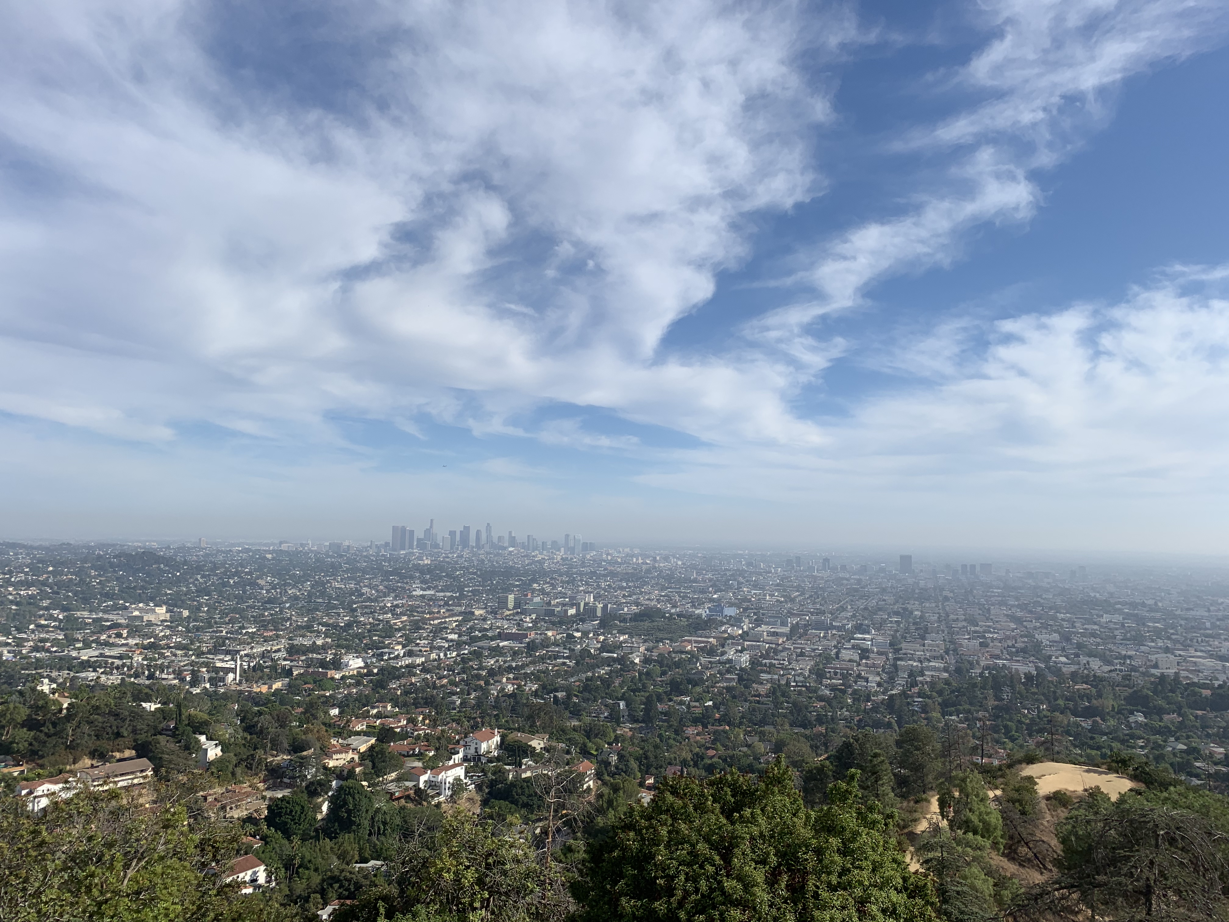
After a whirlwind tour of Hollywood, we saved enough time to make it to Griffith Observatory. I hadn’t really done any research on it- I only knew that it had great views, and a telescope, which unfortunately I wouldn’t be able to look through, as we had the concert to go to that evening. We drove back to LA and navigated our route to the observatory. Parking was a bit nightmarish; the only parking left was parallel parking up along the winding, desert hillsides headed up to the observatory. It is metered pay parking for $10/hr. We decided two hours was about all the time we had to look before heading back to Glendale to get ready for the concert.


We hurried hiked from the car up to the observatory. It looked a hundred miles away but was probably about a kilometre from where we parked, which I definitely felt, hiking uphill in the afternoon California heat. The smog from the morning was dissipating, so it was starting to get warm (keep your sunscreen handy and bring some bottled water).


We explored Griffith Observatory (admission is free!), which was quite remarkable with numerous space exhibits, huge planetary displays, and of course a theatre named in Leonard Nimoy’s honor. We could have spent hours learning about the Tesla Coil, tides, moon phases, seasons, spectroscopy and looking through the camera obscura that peers over the city, but we only had time for a brief walk through.


We headed outside to the garden and outdoor area to take in some stunning landscapes of the city before leaving to head to the concert. This is a place I could have spent a full day (and evening) at. There is so much to learn here; they have star parties, theatre presentations and educational events and the outdoor views are stunning. I can only imagine they’re also stunning at night. Griffith Observatory is a must see when in LA and I was sad to have not had enough time to take it all in.


The Greek Theatre. I’d seen it in movies and I knew it had been designed in the style of an ancient Greek theatre. This was one of the most magical nights. The sun began to set as we got to our seats but the air was still pleasant and warm. As it got darker and the opening band was playing, I was actually pretty overcome with how gorgeous the venue was; crickets were chirping, the forest and hills around us were lit beautifully. Off in the distance where the moon was rising, the city lights were twinkling in the dusk and planes were landing and taking off at the distant airport. The whole atmosphere was just beautiful and I had a few moments of being taken aback at how perfect everything was in that moment. The bands were phenomenal and only added to how great the experience was. At the end of the concert, we did have to walk a ways down from the venue to find a taxi (I know, I know, but we don’t UBER) to get back to our little motel in Glendale…


Ben Folds at The Greek Theatre


On our final morning, we went for breakfast at Foxy’s in Glendale, which had a lot of greasy breakfasts to choose from (so much cheese) but a super gorgeous little patio. After breakfast we walked across the street to find The Americana at Brand, a shopping complex we’d heard was nearby, but hadn’t seen yet. We walked down a little alleyway, and a bit like walking through Diagon Alley in Harry Potter, we emerged in a gorgeous shopping plaza with stunning garden areas, cobblestone streets and adorable boutique shops. Only a few coffee places were open this early, but there were gardeners and maintenance workers cleaning the streets, stringing up lights and busying themselves with tasks. It was so quiet, peaceful and fresh.

Breakfast at Foxy’s


 We’d scheduled in just enough time to head to Playa del Rey on the way to the airport before flying home. We parked and found a little lagoon, and then made our way to the beach. While we were headed through the burning sand to get to the ocean, I head distinct “borking”. I looked towards a rough concrete pier in the water where the “bork” had come from and watched a sea lion dive under the water! I was thrilled, as was my husband. He’d read that sea lions could often be spotted here, which I didn’t know. He didn’t tell me in advance, as he was afraid I’d be disappointed if I didn’t see one, so he was happy that I’d been surprised by the treat of seeing a sea lion in the wild. We continued to hear them bark as we made our way to a cute cafe, Playa Provisions, for lunch. We had a nice, healthy meal here before finally having to make our way to the airport and head home.


 Three days wasn’t nearly enough time to spend in Cali, but we certainly did make the most of our time. At the time, we couldn’t have foreseen the coming pandemic events and this was our last trip, at least internationally for the time being. Even though LA is crowded and has issues with homelessness, poverty and pollution, there’s just something about it that I love. We made great memories in the City of Angels for Shawn’s milestone birthday and California will always have my heart. TTFN. ‘Til we meet again.
– L
Staycation Alberta: Siffleur Falls and the story about how I never made it there twice
Posted on August 31, 2019
 I’m not much of a hiker, but I’m working on my irrational fear of bears and I always try to do things that scare me in order to deal with and conquer my fears. I’ve come a long way in the past few years with a successful 17 km round trip to both tea houses at Lake Louise three years ago and a successful hike to the gorgeous Grassi Lakes in Canmore last year.
About six years ago was one of my first attempts at a hike in bear country since my fear started. My husband and I and our pug Lexi, were on a camping trip at David Thompson Resort and Shawn wanted to try a hike. We’d heard about the popular Siffleur Falls hike nearby and it sounded doable. Back then, I didn’t carry bear spray and I was an ill prepared hiker.

I did okay for the first 20 or so minutes. We crossed the suspension bridge that crosses the Saskatchewan River. I began to get anxious when we got to the boardwalk area, which seemed like the perfect meadow area for bears to be at home in. My anxiety peaked when we reached a narrow closed in section of the trail where I couldn’t tell if my fear was overtaking me or if the feeling I was having of feeling “watched” was paranoia or was my instincts- it’s sometimes said if you feel like you’re being watched, you could be being stalked by a predator- and they have mountain lions here too. Even though I thought I could hear the waterfall ahead, my fear became too much with the trail being not densely populated and with my appetizer of a dog, I forced our little family to turn around. Even though I was alive, I was really disappointed in myself for letting my fear run wild.

The Saskatchewan River and suspension bridge
Fast forward to this June. I had the chance to redeem myself. We were camping nearby again and I decided I’d be amenable to give it another go. Better prepared with rain gear, bear spray, a few snacks and confidence from recent successful hikes where I didn’t get eaten or lost forever, we trekked out. I made it over the bridge, through the meadow and boardwalk and actually made it to the Siffleur River Bridge (that last time I’d mistakenly thought was the waterfall nearby). I carried in bravely even thought the trail was again, not very busy and began to close in with thick brush. We followed the trail and passed warning signs that we were now in back country. In quiet, densely forested areas, I requested that Shawn tell me very LOUD STORIES as we headed further back into the mountains. We came to a bit of a fork with 2 trails with a trail head marker that was not longer there. After some discussion we decided to take the trail that looked more “used”.

Crossing the Saskatchewan River

Suspension bridge at the Saskatchewan River

This took us up a steep trail and I realized we’d been walking for a while and was surprised to hear the sound of rushing water getting quieter, which I thought was odd, since we were hiking to falls. There were few markers and the obvious paths were getting less clear. My Garmin activity tracker told me we’d been hiking for well over 4km at this point so we checked the rudimentary map we’d gotten from the campground. It was then that we noticed the map (unlike the others we’d gotten for other nearby hikes) was listed in “hours” and not kilometers or miles. We didn’t have any idea how long we’d been hiking for, but guessed about 45 mins to an hour. The location of our falls was listed at 2.5 hours, which would make this at very least, a 5 hour return trip. Even though I’d prepared better, I hadn’t brought extra clothes or enough food to spend a night (worst case scenario in the mountains). There were very few other hikers and no cell service in case something happened. We hadn’t let anyone know we were on a hike, as we hadn’t expected this one was so long. We hadn’t set out particularly early and if we ate our snack on the way, we would have had nothing else for an emergency situation. Since we had no idea how much longer the hike would take (at this point we were starting to wonder if we were still on the correct path) and since we still weren’t prepared for a potential night in the back country, we decided to turn back.

Boardwalk along the first part of the Siffleur Falls hike

Getting into backcountry

Leaf miner damage on some of the leaves

Wild Orchids! Beautiful!

Round leaf orchid
I was again, very disappointed in myself, but at least this time I didn’t turn back because I let irrational fears get the best of me. Maybe I was over cautious about the potential things that could go wrong, but I also didn’t want to be a statistic and need rescuing from a mountain park. In my frustration about still not making it to the damn falls, I have to keep in mind that we didn’t have great information from the map or the trail information at the trail head and I can use that as a lesson for the next time. When we returned and checked to see if we’d missed something obvious, we noticed that someone had written 4.4 km by hand on the map. Obviously, that’s not the kind of information one can necessarily trust either; who wrote it? How did they track it?

A beauty day for a hike

Crossing the Siffleur River bridge

Siffleur River

Siffleur River

Hiking back after turning around

Star-flowered False Solomon Seal

Red Paintbrush. One of my favorite alpine wildflowers
So Siffleur falls wins again. At the end of the day, we’d had a nice hike, the views were stunning, we found gorgeous flowers and I’m happy that I made it farther than last time. Maybe the third time will be a charm, with an early start, a full pack and a big can of bear spray.
Have you made it to Siffleur Falls? How was your hiking experience? Have you ever encountered misinformation about a trail? Thanks again for stopping by to read. Feel free to comment or ask questions! Until next time, safe and happy travels!
-L
Staycation Alberta: Camping at DTR
Posted on August 5, 2019
 I interrupt my Thailand ranting to bring you and episode of Staycation Alberta. We’re now in prime camping season in Alberta, and it’s a short season. My husband and I almost never vacation at the same spot twice; we feel that there is too much of this giant globe to explore to settle down at one vacation spot. Our one exception to this rule is David Thompson Resort. We have camped here in various forms for years as a couple and individually with our families when we were kids. DTR, as it’s affectionately known, is found on the David Thompson Highway heading west from Red Deer and Rocky Mountain House. Along the way you’ll come across the hauntingly beautiful Abraham Lake. It’s a turquoise color not unlike the seas around Antigua, but Abraham Lake has a weird ghostlyness to it. The area is generally still and quiet and visually is unique from the rest of the Rocky Mountains. This area is less popular than the Rocky Mountain national parks but is only about a 40 minute drive to Saskatchewan Crossing where you can enter Banff National Park and head north to Lake Louise or Jasper, or south to Banff, Canmore or Kananaskis.

Driving in on the David Thompson Highway

A lunch stop at Goldeye Lake

A lunch stop at Goldeye Lake

A lunch stop at Goldeye Lake
Previously, we’ve tented here (slept in the van- this is bear country), rented a trailer with an RV company and this time we rented one of the resort’s trailers. DTR has options for tenting, trailers and they also rent a selection of pre-set up trailers if you don’t have your own or don’t have the ability to tow a rental. There is a small selection of cabins to rent as well. DTR does group camping, has a small amphitheater and even a wedding venue. There are basic washroom facilities with pay showers and even a communal kitchen wash station, which is handy when your Coleman stove bites the bullet and you have no way to make hot water…

Our rented trailer

View from the campsite
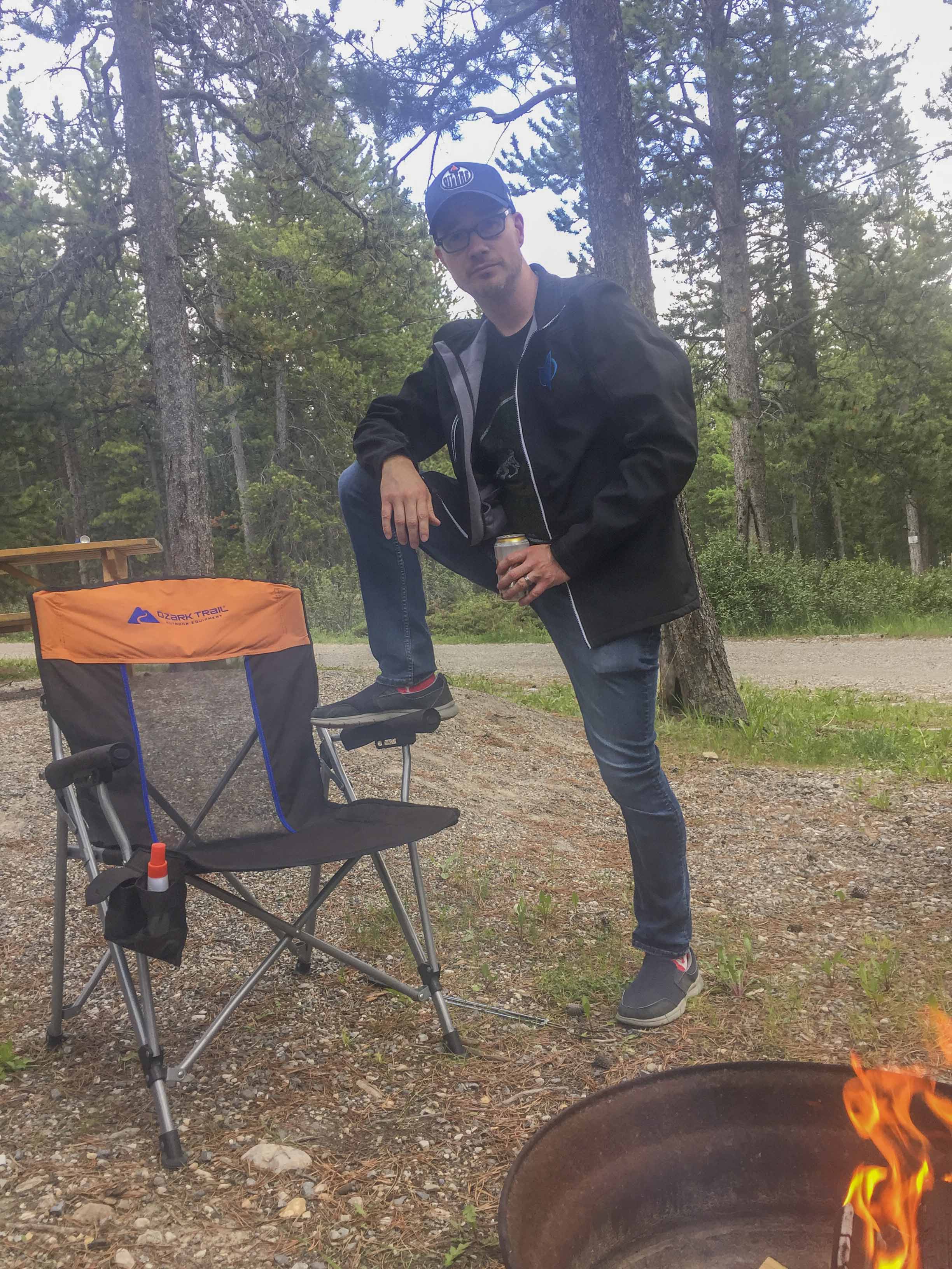
Shawn mugging for the camera
There is a quaint motel with laundry facilities, a restaurant, convenience store with all the extra camping things you may have forgotten, and gas station. There are two parks for the kids to play in and a mini golf course. During peak season on Friday and Saturday nights, they have a rustic bar in the camping area to gather with friends (or make new ones) and they serve a cowboy breakfast (for a fee) in the mornings on weekends. Being in the middle of the wilderness, internet is still iffy, but they have free gust WiFi at the hotel lobby, so it’s a good way to really disconnect for a bit. DTR also allows dogs, just not in their trailers.

Shawn re-living his childhood in the giant rocket
If you’re not one for sitting around the fire the entire trip, there are lots of nearby activities. There are some really cool hikes down to the lake from the camp site, but lots of really great other hikes a short drive away as well. Usually the staff are fairly knowledgeable about hikes and activities in the area. The hikes in this area are much quieter than the crowded national park trails, so you may have a lot to yourself (bring your bear spray). There’s a helicopter base just down the road where you can book a trip to see the mountains like never before, there’s a trail riding company across the highway and an interpretive fire trail with information about the controlled burn done in 2009 where you can hike through the burn area. If you’ve got a vehicle that can handle a bit of off-roading, there are lots of cool places off the highway and along the lake to explore.


Taking a late evening hike to Abraham lake on the summer equinox. Plenty of daylight left.


Abraham Lake


A cairn down by the lake


Gorgeous golden hour

This next set of photos is from our trip last year, when we took Lex with us (and stayed in the van). We did some exploring around Abraham Lake and its shores:


I was delighted to find out this year that DTR even has hummingbirds as regular visitors to the area during the summer. I spent a few mornings stalking them on the restaurant patio:


If you’re looking for a place to camp that’s nestled in the mountains, quiet and away from the city, but still has amenities, this is the place you should check out the summer.
Have you been to David Thompson resort before? What are your favorite Alberta mountain camping getaways? As always, feel free to comment or ask questions. Thanks for stopping by and until next time, safe and happy travels!
-L
