Staycation Alberta: Camping at DTR
Posted on August 5, 2019
 I interrupt my Thailand ranting to bring you and episode of Staycation Alberta. We’re now in prime camping season in Alberta, and it’s a short season. My husband and I almost never vacation at the same spot twice; we feel that there is too much of this giant globe to explore to settle down at one vacation spot. Our one exception to this rule is David Thompson Resort. We have camped here in various forms for years as a couple and individually with our families when we were kids. DTR, as it’s affectionately known, is found on the David Thompson Highway heading west from Red Deer and Rocky Mountain House. Along the way you’ll come across the hauntingly beautiful Abraham Lake. It’s a turquoise color not unlike the seas around Antigua, but Abraham Lake has a weird ghostlyness to it. The area is generally still and quiet and visually is unique from the rest of the Rocky Mountains. This area is less popular than the Rocky Mountain national parks but is only about a 40 minute drive to Saskatchewan Crossing where you can enter Banff National Park and head north to Lake Louise or Jasper, or south to Banff, Canmore or Kananaskis.
Driving in on the David Thompson Highway

A lunch stop at Goldeye Lake

A lunch stop at Goldeye Lake

A lunch stop at Goldeye Lake
Previously, we’ve tented here (slept in the van- this is bear country), rented a trailer with an RV company and this time we rented one of the resort’s trailers. DTR has options for tenting, trailers and they also rent a selection of pre-set up trailers if you don’t have your own or don’t have the ability to tow a rental. There is a small selection of cabins to rent as well. DTR does group camping, has a small amphitheater and even a wedding venue. There are basic washroom facilities with pay showers and even a communal kitchen wash station, which is handy when your Coleman stove bites the bullet and you have no way to make hot water…

Our rented trailer

View from the campsite

Shawn mugging for the camera
There is a quaint motel with laundry facilities, a restaurant, convenience store with all the extra camping things you may have forgotten, and gas station. There are two parks for the kids to play in and a mini golf course. During peak season on Friday and Saturday nights, they have a rustic bar in the camping area to gather with friends (or make new ones) and they serve a cowboy breakfast (for a fee) in the mornings on weekends. Being in the middle of the wilderness, internet is still iffy, but they have free gust WiFi at the hotel lobby, so it’s a good way to really disconnect for a bit. DTR also allows dogs, just not in their trailers.

Shawn re-living his childhood in the giant rocket
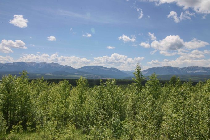
If you’re not one for sitting around the fire the entire trip, there are lots of nearby activities. There are some really cool hikes down to the lake from the camp site, but lots of really great other hikes a short drive away as well. Usually the staff are fairly knowledgeable about hikes and activities in the area. The hikes in this area are much quieter than the crowded national park trails, so you may have a lot to yourself (bring your bear spray). There’s a helicopter base just down the road where you can book a trip to see the mountains like never before, there’s a trail riding company across the highway and an interpretive fire trail with information about the controlled burn done in 2009 where you can hike through the burn area. If you’ve got a vehicle that can handle a bit of off-roading, there are lots of cool places off the highway and along the lake to explore.


Taking a late evening hike to Abraham lake on the summer equinox. Plenty of daylight left.


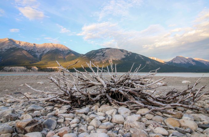
Abraham Lake


A cairn down by the lake


Gorgeous golden hour

This next set of photos is from our trip last year, when we took Lex with us (and stayed in the van). We did some exploring around Abraham Lake and its shores:


I was delighted to find out this year that DTR even has hummingbirds as regular visitors to the area during the summer. I spent a few mornings stalking them on the restaurant patio:


If you’re looking for a place to camp that’s nestled in the mountains, quiet and away from the city, but still has amenities, this is the place you should check out the summer.
Have you been to David Thompson resort before? What are your favorite Alberta mountain camping getaways? As always, feel free to comment or ask questions. Thanks for stopping by and until next time, safe and happy travels!
-L
Staycation Alberta: Roadtrip to Ram Falls
Posted on July 7, 2018
 Last year I had surgery and was off work for 6 weeks. Towards the end of my leave I was getting cabin fever so my Mom offered to take me on a road trip; something easy, she would drive, all I had to do was sit in the car and walk around when we got out for stops along the way. Mom lives in Red Deer, Alberta which is pretty much in the middle of our province. It’s a pretty easy drive to get to the mountains if you head west, and that’s what I wanted to do. She remembered having done a trip to Ram Falls out near Nordegg, Alberta, decades earlier, so we decided on that. We packed a lunch and brought my dog, Lexi along for the adventure.

We headed out west from Red Deer fairly early. According to the GPS maps, we guessed it would take about 2 hours to drive there. Since Ram falls is tucked fairly deep into the foothills of the mountains, Mom suspected the roads may be secondary highways or even gravel trunk roads that would be less maintained than the main highways. We made our way out on Highway 11\22, turned onto Township road 392 and then a left at AB-782 W. It was our plan to meet up with Forestry Trunk Road AB-40 but that didn’t happen. The trunk road at 752 did turn into a gravel road, as Mom expected and it was rough. Really rough. She put her foot down (not literally) and turned the car around. Because I was still recovering from surgery, she was concerned the bumpy road was not conducive to my condition. I’m not going to lie; I was mad.

The gravel trunk road out to Ram Falls
I was so excited to take a back road; mysterious and serene, to explore the wilderness. We headed back south on highway 766 and were deciding what to do instead, but I was really upset; I’d been cooped up all spring and would have to work through most of the summer once I went back to work and I really wanted to do this trip. We argued about it a bit and Mom remembered that there may be a secondary route to get to Ram Falls, and finally agreed to try the alternate route, as long as the gravel roads there were less bumpy. YAY!
We re-routed and headed out on highway 54 through the small town of Caroline. Caroline Alberta is located in Clearwater County, and it’s kind of the unofficial “Sasquatch corridor” of the province. Many Bigfoot sightings get reported here.


I’m serious; there are dedicated blog sites and eyewitness accounts of Bigfoot sightings. Honestly, its so densely wooded and starts to get isolated from town with the foothills of the mountains beginning here, it makes a person wonder what could be lurking in the forests… But the county seems to have used the Bigfoot rumors in a clever way, with the Sasquatch and Partners program. Their message of environmental stewardship draws attention to looking after nature and being respectful, safe, and ecologically sound while enjoying the wilderness. There were quite a few Sasquatch signs and memorabilia as we headed west. Makes a person think…..

Anyway, we did finally hit another gravel road as we continued onto highway 591, but Mom and I agreed that this road felt less bumpy but she warned me that if she thought it was getting worse she would again “turn the car around”. Luckily, there weren’t too many bad spots and she drove slowly in some of the rutty spots. Along the way we passes a lot of off-the-grid campers. We hadn’t yet reached the area that becomes a provincial park area, and while I’m not sure if legal, there were plenty of campers, ATVs, and all manner of “toys” pulled off the road at makeshift camp sites. I’d highly advise a full tank of gas and a spare tire or two (with the knowledge of how to change it) for this trek, but there was enough traffic that we weren’t completely alone. Even so, it was still a pretty quiet, back country drive. We drove through some pretty farmland, rolling hills with Texas gates and saw lots of free roaming horses and cattle.


We stopped for a picnic lunch at Elk Creek, a tiny, remote, unserviced campground. What a pretty spot. So quiet you just hear wind rustling through thousands and thousands of pine trees. Some pretty birds hung around and a few chipmunks that clearly know that people have delicious snacks paid us a visit. We explored around Elk Creek and stretched our legs before continuing.

Lunch at Elk Creek

Mom and Lexi
As we got close to Ram Falls, the roads started to get steeper and more mountainous. The landscape opened up and as we crested one hill, down below the hillsides and carved out ravines we began to see were black. Stunning and a bit spooky, apparently these rocks are formed from a different type of shale than in a lot of the rock found in the rocky mountains further west.

Black shale rock

There is a cool orange covered bridge that crosses the South Ram River which contrasts beautifully with the black shale rock hillsides. You might spot a few mountain sheep along the hillside and roadway, if you’re lucky.

Crossing the South Ram River
The entrance to the Ram Falls lookout point is slightly further past the covered bridge and is well marked. We weren’t sure how accessible the falls lookout point was from the parking area. Mom certainly didn’t want me doing a long hike through rough terrain to get to the falls. She stopped a fellow visitor who told us it was a short, easy walk to a well built staircase down to the falls. Mom didn’t let me go down the entire staircase, so if you go, you’ll get an even better view of the falls than I did. Ram River Falls are quite stunning.


Ram River Falls


 Had I not been on medical leave, I would have loved to go all the way down to get a better view, but in addition to my recent surgery, Lexi wasn’t a big fan of all the steps and the open railings. While totally safe for people, it would have meant a big drop off if the small dog had missed a step or sniffed too far over the edge. We spent about an hour at the falls and then headed back out on highway 374/AB-40 north which was still gravel until we got to Nordegg, where we stopped again for a bathroom break and a stretch.


Heading back home through Nordegg
 The Nordegg area has a lot of great camping spots. A lot are unserviced, but if you can live off the grid for a few days, you won’t be disappointed.

A distant prescribed burn in the Rocky Mountains

The route we took
Because of our backtracking and little detour down through Caroline, we used a good portion of the day and didn’t get back to Red Deer until after dinner. It was a great day, spending quality time with Mom and Lexi in pristine, nearly untouched nature. I can’t wait to go back and camp at Elk Creek, and I think you should too. Have you been out this way? What’s your favorite camping spot? Drop me a line if you like, and happy travels!


All Photos © Eterno Dia Photography and Leslie Pallier Winter 2018.
Tales Of An Angry Chipmunk
Posted on July 25, 2013
I was camping out near Nordegg, Alberta in June. I heard some incessant chirping and when I went to investigate I was surprised to find this angry little chipmunk instead of a bird. He led me around for a few minutes before he scurried off into the brush, all the while telling me how upset he was. Enjoy!
